Category Paving the Way for Apollo 11

Ranger triumphs

SUCCESS AT LAST

Ranger 7 was mated with its launch vehicle on 6 July 1964. The countdown began early in the morning of 27 July, but was scrubbed owing to a problem with the Atlas. It lifted off at 16:50 GMT on 28 July, the Atlas performed flawlessly, and the Agena achieved a circular parking orbit at 185 km then performed the translunar injection.

As to the target, Maxime Faget of the Manned Spacecraft Center had suggested investigating the crater made by its predecessor in order to use that calibrated impact to calculate the strength of the surface material, but the Moon was ‘full’ on 24 July and ‘last quarter’ on 1 August, with the result that the Sun would have set for Mare Tranquillitatis. After an analysis found that the best region would be in the vicinity of Guericke in Mare Nubium, in early July Homer Newell approved aiming for a point where the mare was crossed by bright rays from both Copernicus and Tycho. The translunar injection of 39,461 km/hour was within 6.5 km/hour of that planned. It would have caused the spacecraft to skim the leading limb of the Moon and crash on the far-side. The 50-second midcourse manoeuvre at 10:27 on 29 July established the desired trajectory. Afterwards, the terminal approach was analysed in terms of the angle of illumination of the lunar surface, the direction of the velocity vector of the spacecraft and the optical axis of the camera system, and it was decided that no terminal manoeuvre would be required for the photographic operation on 31 July.

The 3-storey Space Flight Operations Facility had been completed several months earlier. It had a main room for engineers and controllers, and nearby science support rooms for scientists to receive and analyse the incoming data. All these rooms were windowless for 24-hour use. Homer Newell, Edgar Cortright and Oran Nicks joined W. H. Pickering in the VIP gallery. Harris Schurmeier and Patrick Rygh supervised the flight control team. Gerard Kuiper’s experimenters congregated in their room. With 20 minutes remaining, George Nichols informed the auditorium that the wide – angle cameras had started to warm up. The duration of this process had been halved, and 90 seconds later he reported they were on full power, prompting a round of applause. These cameras began to take pictures at 13:08:36. The narrow-angle

cameras followed suit at 13:12:09. It was early morning at JPL, but there was a large crowd of technical staff on hand, and they applauded and cheered when Goldstone announced that both video streams were coming in. Impact was at 13:25:49, within 12 km of the aim point.1 This was the first American lunar spacecraft of any type to fully achieve its mission. Schurmeier produced several cases of champagne for the flight controllers, then led the VIPs to join the experimenters.

When Pickering, Newell and Schurmeier entered the auditorium an hour later for a press conference, they received a standing ovation. A total of 4,316 pictures were received. The first was taken at an altitude of 2,100 km and the last at about 500 metres. Goldstone converted the signal to TV format, and simultaneously stored this on magnetic tape and displayed it on a high-speed monitor. A camera whose action was synchronised with the incoming frame rate recorded each TV frame on 35-mm film – this film was then transferred to a vault. As this was going on, a technician ‘sampled’ another screen using a Polaroid camera to provide an initial evaluation of the quality of the results. The tape was replayed to make another film that was flown to the Hollywood-Burbank Airport for processing by Consolidated Film Industries. In the late afternoon local time, prints and slides were driven to JPL. While the experimenters examined the masters, the VIPs viewed copies. The press conference

Подпись: 1

image47

The crater that Ranger 7 made was identified in Apollo 16 photography in 1972.

by the experimenters that evening was broadcast ‘live’ by the national TV networks. After Pickering introduced the team, Kuiper, the principal investigator, began the presentation: ‘‘This is a great day for science, and this is a great day for the United States. We have made progress in resolution of lunar detail not by a factor of 10, as hoped would be possible with this flight, nor by a factor of 100, which would have been already very remarkable, but by a factor of 1,000.’’ In fact, he was being a little optimistic, as the resolution of the final frame was about half a metre.

The experimenters were obliged to provide ‘instant science’, to explain what the pictures showed.

Harold Urey pointed out that he was ‘‘pleasantly surprised’’ at the amount of information that could be inferred from the pictures. The surface was cratered, right down to the limiting resolution of the final frame. The bright rays appeared to have been formed by ‘secondary’ impacts as ejecta fell back on low-energy ballistic trajectories from an energetic ‘primary’ impact. Science fiction authors had reasoned that since the Moon had no atmosphere there could be no erosion, and this had led artists to depict an extremely rugged landscape. The fact that the surface was gently undulating was clear evidence that the incessant rain of meteoritic material was a potent form of erosion. Urey introduced the term ‘gardening’ to describe the process by which impacts ‘turn over’ the material.

Kuiper said the pictures supported his belief that the mare plains were lava flows, the surface of which, having been exposed to the vacuum of space, must be ‘frothy’. This was based on laboratory experiments in which fluids of various viscosities had been exposed to vacuum. He ventured that when an astronaut walked on the surface, the experience would be similar to walking on crunchy snow. He accepted that there would be a layer of impact-generated fragmental debris, at least in some places, but thought it would be very thin, perhaps no more than a few centimetres.

Given the presence of large and obviously heavy blocks of rock, Gene Shoemaker was confident that the surface would bear the weight of a lander.

Nevertheless, Thomas Gold of Cornell University, who was not on the experiment team and not at the conference, had a theory that the maria were deep accumulations of fine dust. On seeing the Ranger 7 pictures Gold told reporters that whilst the dust would flow and tend to smooth out small-scale deformations, the rate at which it did so might be as little as a millimetre per year. As evidence of such flow, he pointed out that the rims of the older-looking craters were softer than the rims of the newer – looking ones.[22]

Although the Ranger 7 results were consistent with the ‘hot Moon’ hypothesis, in which the maria were volcanic lava flows, Urey did not give up on his ‘cold Moon’ hypothesis in which they were splashes of impact melt.

Several days later, Robert Gilruth, the Director of the Manned Spacecraft Center,

image48

image49

image50

image51

image52

image53

An oblique view of the plaster model of the lunar surface made by the US Geological Survey’s Branch of Astrogeology on the basis of the final high-resolution images from the Ranger 7 spacecraft.

and Joseph Shea, the Apollo Spacecraft Program Manager in Houston, visited JPL to be briefed by the experimenters. Shea later told reporters that in the pictures much of the mare plain appeared “relatively benign’’. Overall, Gilruth said, an Apollo landing should be “easier than we thought’’.

On 28 August NASA hosted the Interim Scientific Results Conference, chaired by Oran Nicks. The visual highlight was a 5-minute movie of successive frames of the picture sequence showing Ranger 7’s dive. Immediately afterwards, the experiment team went to the International Astronomical Union meeting in Hamburg, Germany, and showed the movie again. The Union designated the Ranger 7 target area Mare Cognitum – the Known Sea. Shortly afterwards, as the pictures were being used to make an atlas of this region, Gerard Kuiper marvelled, “To have looked at the Moon for so many years, and then to see this. . . it’s a tremendous experience.’’ Ranger 7 gave a flood of data to a community which had been starving for years. The population statistics for primary projectiles is such that there is a small number of really large ones and increasing numbers of ever smaller ones. An airless surface exposed to such a population will gain many small craters, and progressively fewer larger ones. Given actual numbers for the populations, the cratering density (derived from counting) provides an age estimate – at least in terms of a presumption of how the population of projectiles changed over time. The simplest hypothesis is that this has remained constant, so that although the sheer number of potential projectiles has declined, their proportions have remained the same. It was evident that large caters would stand apart, but there would be a size of crater at which a given surface would be saturated – i. e. such craters would be so numerous that they would be rim to rim, and each new crater would mask an old one. This saturation would produce a sharp transition in the ‘crater curve’. Dating by this method can be done only using craters which exceed the saturation size. It was not possible to determine this telescopically, but Ranger 7’s pictures enabled the saturation size for this patch of Mare Nubium to be estimated at 300 metres. At less than this size, the surface was in a ‘steady state’. The areal coverage of Ranger 7 did not include many craters larger than 300 metres, but William Hartmann at the Lunar and Planetary Laboratory of the University of Arizona attempted the measurement and derived an age of 3.6 billion years. During the 1950s C. C. Patterson at Caltech had radiologically dated a number of meteorites, and reached the conclusion that the solar system formed 4.55 ( + 0.07) billion years ago. If the Moon formed at that time, Hartmann’s crater counting indicated that the surface of Mare Nubium was about a billion years younger.

While the scientists digested the Ranger 7 results, there was a hiatus in the project to accommodate the launches of Mariner 3 and Mariner 4 in November 1964, which also used the Atlas-Agena and hence the same pad facilities at the Cape.

SCIENTIFIC TARGETS

On 7 March 1967, several days after Lunar Orbiter 3’s readout was curtailed, the project established a working group to develop the strategy for the final mission of the series. It was decided that if Lunar Orbiter 4 was successful in its mapping, then Lunar Orbiter 5 should undertake a scientific mission involving multiple targets. The photographic objectives were: (1) to obtain additional near-vertical, stereoscopic and westward-looking oblique frames of the eastern candidate sites for the early Apollo landings; (2) to accomplish broad survey coverage of those portions of the far-side which had been in darkness during previous missions; (3) to obtain pictures of sites of interest to the Surveyor project; (4) to reconnoitre potential targets for advanced Apollo landings – i. e. sites outside the equatorial zone; and (5) to take a close look at as many scientifically interesting sites as possible. The main criterion for a site being considered to be interesting was its perceived ‘freshness’. The pictures from Ranger and the Lunar Orbiters to date had revealed most lunar terrain to appear subdued, so it had been decided to seek terrains which had not been exposed for long enough to have been significantly weathered by the incessant rain of material from space.

The preliminary plan was put to Boeing on 21 March, and a meeting on 26 May designed an orbit that would enable the spacecraft to address the widely distributed targets without violating any of its operating constraints. It would have to fly in a near-polar orbit to gain the latitude coverage, on a track with the Sun at an elevation of between 8 and 24 degrees to highlight the topography, and the perilune at about 100 km to provide the requisite 2-metre resolution.

Lawrence Rowan had led the US Geological Survey’s participation in the Apollo site selection process, but he stood down after Lunar Orbiter 3. Donald E. Wilhelms took over this role for Lunar Orbiter 5, with its focus on advanced Apollo missions.

On 15 March Bellcomm had hired Farouk El-Baz, an Egyptian geologist with a PhD from the University of Missouri, and he undertook much of the organisational work. Whereas the sites short-listed for the early Apollo landings were on open plains with as few craters and rocks as possible, it was evident that advanced landings would be best made at sites where craters had excavated boulders. And, of course, there were mountains, rilles and features which appeared to be of volcanic origin. However, to be viable a target required a clear line of approach from the east, and this favoured interesting sites adjacent to smooth plains over which an Apollo lander could make its approach. Of course, if the landing site was several kilometres from the ‘feature’ that attracted the interest of the selectors, some form of surface transportation would require to be provided in order to enable the astronauts to reach their true objective.

On 14 June the Surveyor/Orbiter Utilisation Committee approved the overall plan. The initial target list was compiled largely from telescopic studies, but almost half of the items were revised following a review of the Lunar Orbiter 4 results. The agreed objectives were (1) to inspect 36 sites of scientific interest on the near-side, (2) to obtain additional views of five potential Apollo sites and a number of Surveyor sites, and (3) to map most of the far-side that had not previously been covered.

Lunar Orbiter 5 lifted off at 22:23:01 GMT on 1 August 1967. Its Canopus sensor had difficulty finding its target star, but locked on in time for the 26-second, 30-m/s midcourse manoeuvre at 06:00 on 3 August. A 508-second, 644-m/s insertion burn initiated at 16:48 on 5 August attained a 195 x 6,028-km orbit inclined at 85 degrees with a period of 8 hours 27 minutes. The phase of the Moon was ‘new’ on 6 August, and would be ‘full’ on 20 August. Most of the far-side pictures were to be taken in this initial orbit. The first picture was taken at 23:22 on 6 August, near apolune. An 11.4-second burn at 08:44 on 7 August lowered the perilune to 100 km. At 09:05 an impromptu picture was taken of Earth. A 153-second burn at 05:08 on 9 August lowered the apolune to 1,500 km and reduced the period to 3 hours 11 minutes. The Bimat was cut at 03:30 on 19 August, and the readout was concluded on 27 August.

The Apollo sites had been assigned 44 frame-pairs, which was about 20 per cent of the total. The sites of scientific interest on the near-side had included the rilles in Mare Serenitatis near the crater Littrow and near Sulpicius Gallus; some lava flow features in Mare Imbrium; the craters Copernicus, Dionysus, Alphonsus, Dawes and Fra Mauro; secondary craters associated with Copernicus; the Aristarchus plateau; and small domes near Gruithuisen, Tobias Mayer and Marius. All of these sites were regarded as possible targets for advanced Apollo missions.[37]

On 21 January 1968, during the extended mission, the 61-inch telescope of the University of Arizona successfully photographed the orbiter against the stars when it was at apolune. Ten days later, the spacecraft was deliberately crashed in Oceanus Procellarum.

Astronomers had inferred that either the Moon’s shape or its density distribution (or perhaps both) were irregular. The radio tracking of the Lunar Orbiters did not settle the question of the Moon’s shape, but did yield a major discovery. The early missions in near-equatorial orbits had revealed the Moon’s gravitational field on the near-side to be irregular – after allowing for the variation of velocity with altitude in an elliptical orbit, the vehicles kept speeding up and slowing down. The tracking of Lunar Orbiter 5 in its low polar orbit enabled a gravimetric map to be compiled with sufficient resolution for the ‘anomalies’ to be correlated with surface features. It was found that a vehicle was accelerated as it approached one of the ‘circular maria’ and decelerated afterwards.

Such sites included Imbrium, Crisium, Smythii, Serenitatis, Humorum, Nectaris, Humboldtianum, Orientale and Grimaldi. As the maria were low-lying rather than elevated landforms, it was apparent that they must be of a greater density than their surroundings. One early suggestion was that the ‘attractor’ was the buried body of the impactor which excavated the basin that was later filled in by mare material, but this hypothesis was rejected when it was realised that there were negative anomalies associated with basins that had not been filled in by maria. John O’Keefe argued that the attractor was the infill itself. That is, the anomalies were the due to magma from deep in the interior having erupted onto the surface – gravitational attraction falls off with the inverse square of range, and dense material on the surface would produce a significant local attraction. Negative anomalies included craters such as Copernicus, which had essentially excavated ‘holes’ in the maria. Since the positive anomalies represented concentrations of mass, they were dubbed ‘mascons’. The discovery was reported in a paper in Nature in August 1968 by Paul M. Muller and William L. Sjogren.

If the lunar crust had been able to adjust isostatically to the eruption of dense lava onto the surface there would be no anomalies today; the fact that this had not occurred was evidence that the crust was sufficiently rigid at the time the lava was erupted to support its weight. In 1968 Ralph Baldwin provided an explanation. A basin formed and was ‘dry’ for a while, during which its floor began to adjust isostatically to the removal of the crustal material. But before it could achieve equilibrium, fractures in the floor allowed lava to well up and fill in the low-lying areas. This process of infill occurred in many pulses over an extended time. Being dense, the mare pool tended to sink, thereby forming compression wrinkles in its centre and opening rilles at its periphery. When it was unable to achieve isostatic equilibrium the result was a local mascon. A further realisation (obvious in retrospect) was that the sudden removal of crustal material in the excavation of a basin would relieve the pressure on the mantle below and induce deep melting, which would in turn cause a plume to rise, lift and fracture the floor of the basin, and drive enormous volumes of low-viscosity magma to the surface. A question for further research was why most of the basins on the far-side were ‘dry’ – was the crust thicker on that side of the Moon?

WRAPPING UP

The five Lunar Orbiter missions were launched within a 12-month interval. They suffered various technical problems, but the primary objective of providing pictures in support of Apollo was achieved. Only 78 per cent of the frames were classified as ‘useful’, but a large batch of useless ones were the H frames from the first mission. Although solar flares occurred during missions, photography continued. The worst radiation dose was on 2 September 1966, but the flood of energetic protons did not fog Lunar Orbiter 2’s film. This confirmed the wisdom of using a very ‘slow’ film. The radiation detector data confirmed that the Apollo vehicles and spacesuits would protect astronauts from an average exposure to solar plasma, and indeed from short­term greater-than-average exposure. In all, the five Lunar Orbiters reported a total of 22 micrometeoroid strikes over their entire time in space. The hazard in lunar orbit proved to be about half of that in low Earth orbit. An additional benefit to Apollo from the extended missions of the Lunar Orbiters, was the experience gained by the Manned Space Flight Network in tracking vehicles in lunar orbit. If the existence of mascons had not been discovered prior to the first Apollo mission venturing out to the Moon, the astronauts would have found their orbit varying in an unpredictable (and alarming) manner. This was the value of making a thorough reconnaissance!

Boeing had sufficient parts to assemble a sixth spacecraft, and even before Lunar Orbiter 5 was launched the Office of Space Sciences and Applications considered an additional mission. On 5 July 1967 Lee Scherer explained that this could perform a survey of the far-side at a resolution similar to that provided by Lunar Orbiter 4 of the near-side. One suggestion was that it should carry the gamma-ray spectrometer built for Ranger, in order to make a preliminary map the composition of the surface. On 14 July Homer Newell wrote to Robert Seamans putting the case for launching a sixth mission in November. Seamans refused, in part because it would not directly contribute to Apollo – which was not capable of landing on the far-side.

The scientists had hoped to develop Lunar Orbiter Block II to conduct a series of missions utilising a variety of sensors. In late 1964 the Office of Space Sciences and Applications compiled an experiment list: a gamma-ray spectrometer to survey the abundances of radioactive isotopes on the lunar surface; and infrared experiment to map the surface temperatures; a photometry/colorimetry experiment to determine the variation in the photometric function and colour of the surface material; a radiometer to measure surface thermal gradients; an X-ray fluorescence spectro­meter to survey the relative abundances of nickel and iron on the surface; a solar plasma experiment to measure the spatial and temporal variation in flux and energy distribution of low-energy protons and electrons; a magnetometer to determine whether the Moon had a magnetic field; an instrument to test for a low-density ionospheric plasma; and using the transmitter for a bi-static radar experiment to study the roughness and dielectric properties of the surface. But without the leverage of the Office of Manned Space Flight this proposal failed to attract funding.

MORE SOVIET SUCCESSES

Luna 2 was launched at 06:40 GMT on 12 September 1959, and 33.5 hours later it smashed into the Moon in the triangle defined by the craters Archimedes, Aristillus and Autolycus. On striking the ground at 3 km/sec, the probe would have vaporised. It carried similar instruments to its predecessor. In extending the particles and fields survey down to the surface, it found no appreciable magnetic field and no evidence of a radiation belt. The Earth’s field is generated by electric currents in molten iron in the core. The absence of a dipole field suggested that either the Moon had never developed a molten core, or it had and either the rate of the Moon’s rotation was too slow to generate electric currents or the core had since solidified.9

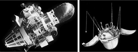
When Luna 3 was launched at 00:44 GMT on 4 October 1959, it was to undertake the eagerly anticipated photographic mission. It was inserted into a highly eccentric orbit of Earth which would provide a view of the far-side of the Moon. The 279-kg probe was 1.3 metres long. The main body was a 1.2-metre-diameter cylinder, and it had solar transducer cells in fixed positions on its exterior. The earlier probes in this series were battery powered, but a battery would not provide the duration required to undertake this particular mission. In addition to particles and fields instruments, the probe had a camera. Its trajectory crossed the radius of the Moon’s orbit 6,200 km to the south of the Moon. The point of closest approach was at 14:16 on 6 October, and lunar gravity deflected the trajectory northward. While coasting, the probe was spin stabilised. On approaching the Earth-Moon plane, beyond the Moon, gas jets halted the spin, a Sun sensor locked on, and the vehicle rolled until another sensor enabled the optics to view the Moon.

The camera had a 200-mm f/5.6 lens and a 500-mm f/9.6 narrow-angle lens, with the optical axes coaligned. Starting at 03:30 on 7 October, at a range of 65,200 km, pairs of pictures were captured simultaneously on 35-mm film which had a ‘slow’ rating in order to resist being ‘fogged’ by the radiation in the space environment. After 40 minutes of photography, the vehicle resumed its spin for stability. The film was wet-developed, fixed and dried. After the probe had achieved the 480,000-km apogee on 10 October, it headed back for the 47,500-km perigee on 18 October. The film was scanned using a constant-brightness light beam which was detected by a photoelectric multiplier whose output took the form of an analogue signal. The scanner had two transmission rates: a slow rate for when far away from Earth and a higher rate for perigee. Contact with the probe was lost on 22 October. On Earth, the signal was recorded on magnetic tape for further processing. The raw images were marred by bands of ‘noise’, which had to be ‘removed’, and the contrast was drawn

A picture taken by Luna 3 on 7 October 1959 showing Mare Crisium (on the left) and a large portion of the hitherto unobserved hemisphere of the Moon.

image26out to emphasise detail. In the wide lens the lunar disk spanned 10 mm, and in the narrow lens it was 25 mm.

The phase of the Moon was ‘new’ on 2 October and ‘first quarter’ on 9 October. Therefore, when the pictures were taken on 7 October a portion of the near-side was illuminated. The prominent presence of Mare Crisium gave a sense of perspective. The remainder of the illuminated zone was 70 per cent of the hitherto unobserved region. As the Sun was directly behind the camera, the lack of shadow detail made it impossible to discern the topography. However, the results did show there to be few dark features – revealing the hemispheres which faced towards and away from Earth to be different. The maria cover 30 per cent of the near-side, but only 2 per cent of the far-side; in total about 16 per cent. The likelihood of there being fewer maria had been inferred from the paucity of maria on the limb, with those present being patchy rather than major plains, but their virtual absence was a surprise. The fact that the Moon’s rotation is ‘tidally locked’ with Earth was evidently an important factor in creating the dichotomy between the two hemispheres.

The results were published in 1960 as Atlas Obratnoy Storony Luny by N. P. Barabashov, A. A. Mikhaylov and Yu. N. Lipskiy. They unilaterally assigned names to the far-side features, with the two most prominent dark patches becoming Mare Moscoviense and Tsiolkovsky.[10] The atlas listed some 500 features of various types on a scale which represented the Moon as a disk 35 cm in diameter.

The Luna 3 mission was a remarkable success for the first attempt at a difficult task.

REPEAT PERFORMANCE

Now that Ranger Block III had proved itself, the Office of Manned Space Flight asserted its right to specify the requirements for future targets. On 16 October 1964 Sam Phillips, the Apollo Program Director, told Oran Nicks that Ranger 8 should investigate a mare plain in the Apollo zone at a position which was not crossed by rays. At a meeting at JPL on 19 November, the scientists argued for comparing the ‘reddish’ Mare Nubium with a ‘bluish’ one in the eastern hemisphere. Nicks made the formal recommendation to Homer Newell on 9 February 1965, who concurred. The target for the first day of the launch window was to be Mare Tranquillitatis, but if the launch were delayed then it would move westward along the Apollo zone to keep pace with the migrating terminator. The launch window for Ranger 8 opened on 17 February. The Moon was ‘full’ on 16 February and would be ‘last quarter’ on 23 February.

Launch was at 17:05 GMT on 17 February. The translunar injection produced a flyby at a range of 1,828 km. The trajectory was refined by a 59-second midcourse manoeuvre at 10:27 on 18 February. When Ranger 8 made its approach to the Moon, it was decided to start the cameras several minutes early so that the initial pictures would be comparable to the best attainable by a terrestrial telescope. A total of 7,137 pictures were received – almost twice as many as from Ranger 7 owing to the extended sequence. Whereas Ranger 7 had made a near-vertical descent west of the meridian, the target for Ranger 8 was 24 degrees east of the meridian and to reach it the spacecraft had to make a slanting approach. Whilst this significantly increased the areal coverage, in particular depicting the central highlands at an unprecedented resolution, it meant there was no overlap between the frames later on and the lateral velocity smeared the final frames. The impact occurred at 09:57:38 on 20 February. Don Wilhelms was watching through the 36-inch refractor at the Lick Observatory near San Jose in California and listening to a radio countdown from JPL, but saw no flash. Alika Herring of the Lunar and Planetary Laboratory was using the 84-inch reflector at the Kitt Peak National Observatory in Arizona, but did not see anything either. As a result of the lack of overlap, the impact point was not actually within the final frame – not that it really mattered, it was calculated from the trajectory as being 24 km from the aim point.[23] In this case, owing to the smearing of the final images, the best resolution was 1.5 metres.

At a press conference 30 minutes later given by W. H. Pickering, Edgar Cortright, William Cunningham and Harris Schurmeier, the latter delightedly summed up the mission as “another textbook flight”.

The experimenters presented some of the pictures later in the day. There were more rocks than at the Mare Nubium site, once again indicating a substantial bearing strength. In fact, this area was one of the ‘hot spots’ in near-infrared measurements made during the lunar eclipse of 19 December 1964, and the exposed rock supported the interpretation of such thermal anomalies as being due to rocks slowly radiating their heat when the Moon entered into the Earth’s shadow.

Despite the intention to investigate a mare site free of rays, it was discovered that Ranger 8 came down over a faint ray from Theophilus. One striking observation was that the surface of Mare Tranquillitatis appeared remarkably similar to that of Mare Nubium. In fact, Gerard Kuiper, showing one of the final frames, remarked, ‘‘If you didn’t know that this was taken by Ranger 8, you’d think it was one of the Ranger 7 pictures.’’ It was ventured that ‘‘probably all lunar maria are pretty much this way’’.

Harold Urey introduced the term ‘dimple crater’ for irregular rimless pits which, it was speculated, might be where loose surficial material had drained into a cavity in much the same way as sand drains in an hourglass. Noting that tubes and cavities occur in terrestrial lava fields, and believing the lunar maria to be lava flows, Kuiper speculated that such pits might pose a ‘‘treacherous’’ threat to an Apollo lander. To Gene Shoemaker, however, they appeared merely to be degraded secondary impact craters.

On the larger scale, the scientists were pleased that as Ranger 8 made its slanting approach it provided views of Ritter and Sabine in unprecedented detail. These two 30-km-diameter craters in the southwestern Mare Tranquillitatis lacked radial ejecta and secondary craters, and their depth-to-diameter ratios made them anomalously shallow in terms of the curve plotted for impacts by Ralph Baldwin. The fact that they were aligned along the Hypatia rilles, were located on the fringe of a mare and had ‘raised floors’ had led some people to interpret them as volcanic calderas. Even people who favoured the impact origin of craters allowed that Ritter and Sabine

image54

image55

image56

image57

image58

might be ‘hybrid craters’ that were excavated by impacts and later modified by volcanism stimulated by their formation – indeed, they were the exemplars of this hypothesis.

Tasting the Moon

A RISKY DESCENT

Surveyor 5 was the first of the project to be assigned to an eastern portion of the Apollo zone. The target was a 60-km-diameter circle in the southwestern region of Mare Tranquillitatis, centred 80 km east of Sabine. The highlands to the west were characterised by prominent southeast-tending ridges and valleys that formed part of the Imbrium sculpture. The target was about 70 km north of the southern boundary of the mare, and 38 km northwest of Moltke. It was also 60 km southwest of where Ranger 8 struck. There were no mare ridges in the immediate vicinity, but the area was crossed by faint rays from Theophilus 350 km to the south. In fact, owing to the magnitude of the gravity turn required to cancel the approach angle relative to local vertical, this site was about as far east as a Surveyor was capable of venturing.

Launch from Pad 36B was at 07:57:01 GMT on 8 September 1967. The Centaur fired for 320 seconds and achieved parking orbit at 08:06:48. It emerged from the Earth’s shadow about 10 seconds later. After coasting for 6.7 minutes, it reignited for the 113-second translunar injection. The spacecraft was released at 08:16:27 and established its cruise mode without incident.

The fact that the initial trajectory would reach the Moon just 46 km from the aim point made this the best performance to date for an American launch vehicle sending a payload towards the Moon. At 01:32:57 on 9 September the spacecraft began to manoeuvre to the attitude for the minor midcourse burn, and at 01:42:28 the squib was fired to open the helium regulator’s valve to increase the six propellant tanks of the vernier propulsion system from their initial pressure of 264 psi to their operating pressure of 720 psi. Immediately beforehand, the helium tank pressure was stable at 5,160 psi. The decrease in helium pressure due to pressurising the propellant tanks was 182 psi, as expected. The burn was initiated at 01:45:02. It lasted 14.25 seconds, and the 45.5-ft/sec change refined the trajectory as desired. As the spacecraft was in the process of re-establishing its cruise attitude, the engineers checking the telemetry were alarmed to observe that instead of holding at 720 psi, the propellant pressure

was rising. It was conjectured that a particle of contaminant had lodged in the seat of the helium regulator and was preventing the valve from closing properly.

There was nominally a 1-hour time constraint between vernier firings, but in view of the need for haste this was waived. Additional firings were made in unsuccessful attempts to clear the valve. As there were bladders in the propellant tanks, there was no mixing of helium and propellant, and whenever the pressure reached 825 psia a relief valve opened to vent the excess pressurant to space. As a result, the helium tank was losing pressure at a rate of about 10 psi per minute. This promised disaster when the vehicle attempted its descent to the Moon, as the verniers would fizzle out from propellant starvation far above the lunar surface.

The first impromptu vernier firing was made with the vehicle’s main axis pointing at the Sun, because the vehicle had already re-established that attitude. The burn was made at 02:12:03, some 27 minutes after the midcourse manoeuvre. It lasted for 10.1 seconds and the change in velocity of 32.1 ft/sec had the effect of driving the aim point 1,600 km along the equator to longitude 77.5°E. This was only a temporary digression, however, because the vehicle was then yawed through 180 degrees and a second burn was initiated at 02:39:51. This lasted 23.0 seconds and the change in velocity of 73.9 ft/sec drove the aim point 2,685 km westward, to longitude 12°W. For these burns the pre-ignition temperatures exceeded the engines’ operating limit, but they fired satisfactorily. Unfortunately, the helium regulator continued to leak.

After a period of deliberation, it was decided to make a third impromptu burn. In addition to a ‘critical component’ of 27.2 ft/sec to re-establish the aim point, there was a non-critical component of 36.1 ft/sec designed both to increase the flight time and to burn off propellant in order to reduce mass and thereby the velocity at retro burnout. To further improve the chances of clearing the regulator valve, the required 13-second duration would be built up by firing the engines for 12 seconds and then twice pausing for 1 second and ‘blipping’ them for half a second. This sequence was started at 04:18:48 and imparted a change in velocity of 45.3 ft/sec, but did not clear the valve.

At 05:50 one team of engineers was assigned to work out a manoeuvre that would enable Surveyor 5 to avoid the Moon and remain in an Earth orbit possessing a high apogee, in case it was decided to abandon the Moon as the target. Meanwhile, other engineers calculated that if sufficient propellant could be burned off to lighten the vehicle and thus reduce the velocity at retro burnout, and if retro ignition were to be postponed to a much lower altitude, then it might be possible to achieve a landing despite the helium problem. At 07:43 it was decided to attempt to accomplish the lunar mission.

The fourth impromptu vernier firing was to burn off propellant in order to further reduce the retro burnout velocity and increase the volume available in the propellant tanks for the helium leaking from the regulator. The latter would both minimise the rate of venting and maximise the impulse available for operating the engines in the vernier descent. The burn was initiated at 08:24:03, lasted 33.0 seconds, changed the velocity by 106.0 ft/sec, and drove the aim point into the central highlands. For the next 13 hours the spacecraft was tracked to precisely define its trajectory. Given the uncertainty about whether a soft-landing would be achieved, it was decided to test the alpha-scattering instrument to check its calibration and assess whether there was a significant cosmic background. Power was applied to the instrument at 10:36. The calibration rates transmitted by an omni-directional antenna were monitored for two 10-minute periods by the Deep Space Network station at Canberra in Australia, then the instrument was switched off at 11:25. The fact that the background was very low was good news; if this should prove to be the only scientific data from the mission, it would assist with the next one. The fifth and final impromptu burn had a critical component of 12.7 ft/sec to draw the trajectory 267 km back towards the target, and a non-critical component of 11.8 ft/sec to further reduce the retro burnout velocity and increase the gas volume in the propellant tanks. ft was made at 23:30:58, lasted 5.45 seconds and imparted a change in velocity of 17.3 ft/sec that returned the aim point to within 30 km of the target. By 23:46:37 the spacecraft had re-established its cruise attitude. The midcourse manoeuvre itself had used 11.3 pounds of propellant, and the impromptu firings had consumed another 67 pounds.

A new descent profile had been devised to minimise the total impulse requirement for the verniers, to enable them to accomplish the landing by operating solely on the residual helium pressurant. On a normal descent the altitude of retro burnout was selected to allow ample time for the verniers to initiate the gravity turn in advance of reaching the ‘descent contour’, but now this margin had to be minimised to reduce the duration of the vernier-only phase of the descent.

The altitude marking radar would still issue its mark at a slant range of 100 km, but the programmed delay would be increased to 12.325 seconds in order to reduce the altitude at which to initiate braking. fn the case of Surveyor 1, whose target was at 43°W, the approach angle had been at 6.1 degrees to the local vertical; for Surveyor 3, at 23°W, the angle was 23.6 degrees; for Surveyor 4, on the meridian, it was 31.5 degrees; for Surveyor 5, aiming for 23°E, the angle would be 46.5 degrees – even on the original plan, this was to have been the most demanding descent to date. fnstead of aligning the thrust axis precisely with the velocity vector, it had been decided to offset it by 0.78 degree in order to enable a component of the powerful retro-rocket’s thrust to contribute to reducing the approach angle, and thereby reduce the gravity turn the verniers would have to perform. And to ensure the most accurate alignment of the retro axis the pre-retro roll was timed for when the divergence in the Canopus sensor would be zero, and the yaw for when the Sun would be precisely aligned in that sensor – as calculated by monitoring the oscillations in the alignment. Whilst the pre-retro sequence in which the vehicle departed from its cruise attitude would usually include a roll to optimise post-landing operations, for this descent the only factor considered was the RADVS, and because the first roll would satisfy this requirement the second roll was deleted. fn essence, therefore, the powered descent would be initiated later than usual in order that instead of retro burnout occurring at an altitude of 35,000 feet this would take place at 4,260 feet, and instead of the total velocity being 400-500 ft/ sec it would be just 100 ft/sec. fn addition, the release of the spent retro-rocket casing was revised to advance the onset of RADVS-controlled flight by 4 seconds – since this time every second would count! These changes were designed to make the most efficient use of the remaining helium pressurant, but the descent would be much more risky than the usual profile.

VELOCITY, FEET PER SECOND

The helium pressurant problem suffered by Surveyor 5 required the burnout of its retro – rocket to occur at an unprecedented low altitude. Note that the 99% dispersion ellipse for retro burnout extends below ground level!

The pre-retro roll of +73.8 degrees was started at 00:12:15 on 11 September, and the yaw of +119.6 degrees at 00:16:20. The altitude marking radar was enabled at 00:43:01 and issued its 100-km slant-range mark at 00:44:39.118, at which time the vehicle was travelling at 8,441 ft/sec. During the specified delay of 12.325 seconds it would travel 104,000 feet, and, in view of the angle of the trajectory, the altitude would reduce by some 74,000 feet prior to retro ignition – this delay being to fly the revised powered descent profile.

The verniers ignited at 00:44:51.443, and the retro-rocket at 00:44:52.533. The helium pressure at vernier ignition was 836 psia, which was sufficient to provide the desired total vernier thrust of 152 pounds for this phase of the descent. The RADVS was switched on at 00:44:53.456, and the radar altimeter locked on at a slant range of 16,000 feet. The acceleration switch noted the peak thrust of 9,740 pounds fall to 3,500 pounds at 00:45:31.355, indicating a burn duration of 39 seconds. The spent casing was jettisoned at 00:45:40.395. The flight control system throttled the three verniers to full thrust at 00:45:40.955 to ensure that the casing fell clear. At burnout, the angle between the thrust vector and velocity vector was 45 degrees.

At 00:45:42.395 control was passed to the RADVS. The altitude was 4,139 feet (a slant range of 6,300 feet owing to the approach angle) and the velocity was 79 ft/sec (the vertical component of which was 46 ft/sec). Attitude control was switched from inertial to radar, and the vehicle immediately resumed the gravity turn by holding a constant deceleration of 0.9 lunar gravity whilst maintaining the thrust in line with the instantaneous velocity vector. At 00:46:19.697 the radar indicated the 1,000-foot mark. On a normal descent, the vehicle would intercept the ‘descent contour’ at a slant range of 18,000 to 25,000 feet, travelling at 400 to 500 ft/sec with 100 seconds remaining to landing. On this revised profile it was to have reached the contour at a slant range of 1,500 feet, but it did so at 806 feet with just 22 seconds remaining for the closed-loop throttling phase. The 10-ft/sec mark was issued at 00:46:37.097, at a height of 50 feet. Some 5.6 seconds later, at 00:46:42.697, the verniers were cut off with a sink rate of 5.2 m/s, and Surveyor 5 fell freely for 1.7 seconds.

After leg no. 1 hit the surface at a vertical rate of 13.5 ft/sec, the vehicle pitched over at an angular rate which was faster than the gyroscopes were able to measure, and 190 milliseconds after first contact the other legs slammed down at 13.8 ft/sec and it came to rest tilted at 19.5 degrees. It was the harshest landing of the project to date, but still within the design specification. Fortunately, the lateral velocity component was negligible and the widely splayed legs prevented the lander from toppling over.

The time spent under RADVS control was a mere 62 seconds. The descent had burned 60 pounds of propellant – a little less than was consumed by the impromptu firings after the midcourse manoeuvre. Although about 45 pounds remained, the issue had not been a shortage of propellant; it was a shortage of helium pressurant to force the propellants into the engines, and by the end of the descent the helium, fuel and oxidiser pressures were identical at 560 psia – in effect, the vernier propulsion system had been in ‘blow down’ mode. Some engineers had estimated the likelihood of achieving a soft-landing at no better than 40 per cent, so this success came as a great relief! The engineering recommendation was to improve quality control in the

The descent of the Surveyor 5 spacecraft depicted in two sections, one for slant ranges above 1,000 feet and the other below 1,000 feet. The delayed retro-rocket braking meant the vehicle did not join the contour until the third segment of the linear approximation to the ideal parabolic trajectory.

The history of Surveyor 5’s helium pressurant from launch to lunar touchdown, showing the leak that developed when the valve of the regulator was activated and the stabilisation of the depleted level by the impromptu midcourse manoeuvres.

A picture taken by the 36-inch refractor of the Lick Observatory showing the southwestern part of Mare Tranquillitatis assigned to Surveyor 5.

manufacture of the helium regulator to eliminate contaminants that could prevent the proper reseating of the valve.

In-flight tracking indicated that it landed some 30 km northwest of the target, at a point that was just off the edge of frame H-78 taken by Lunar Orbiter 5 the previous month – the only high-resolution picture of this particular area – and the best that could be done was to mark a medium-resolution frame with an ellipse based on the post-landing tracking data and give the selenographic coordinates of its centre. The site was either in, or close to, a faint ray from Theophilus.

Surveyor 5 arrived some 35 hours after local sunrise, with the Sun at an elevation of 17 degrees. The first 200-line picture was taken at 02:01, and the entire initial sequence of 18 frames had been transmitted by 02:39. Although it was evident that the lander was on a steep slope, its orientation was uncertain, and this complicated the task of aligning the high-gain antenna. This began to scan the sky at 02:58, with Goldstone monitoring the strength of the received signal and directing the search. Meanwhile, the solar panel locked onto the Sun at 04:10. The antenna finally locked on at 05:21, and the first 600-line picture was transmitted at 05:30.

LENS1

TV AUXILIARY UNIT.

SIGNAL PROCESSOR,

I TRANSMITTER

THERMAL COMPARTMENTS

The camera provided for Surveyor 5 had a modified hood for the mirror assembly.

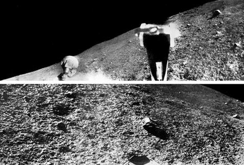
It was soon realised that foot pad no. 1 was resting on the southwestern margin of a small irregularly shaped crater 12 metres long by 9 metres wide and a fraction over 1 metre deep, and the other legs were inside the cavity. The crater was rimless, with the slope increasing towards the centre, where there was a distinctly concave floor spanning about 2.4 metres. In fact, the crater was of a type which had been classified in the Ranger imagery as a ‘dimple’, and the lack of a rim had led some people to argue that such pits marked where the loose surface material had drained into a subterranean space – with the implication that such features were not of impact origin.1 The major axis of the crater was northwest-southeast, and the vehicle was on the southwestern interior wall, tilting northeast. It seemed to be the largest member of a chain of small elongated craters, all oriented with their major axes in line with the chain, and there were other chains in the area sharing this directionality.

Pad no. 1 had struck just outside the crater, and the others on its interior slope. As the vehicle rebounded, it slid downslope, causing pads no. 2 and 3 to scrape furrows about 1 metre long before they came to rest near the base of the wall. So, although this lander did not possess a soil mechanics surface sampler with which to scrape a trench, its legs served this role. As the vehicle slid down into the crater, pad no. 1 was dragged closer to the edge and the fragmental material that it displaced came to rest directly beneath the camera. Furthermore, as pads no. 2 and 3 ploughed their furrows they hinged and drove their outer edges into the surface, causing material to spill onto their upper surfaces where it was conveniently situated for examination by the camera. The furrows varied in depth between a few centimetres and 12 cm, most likely because the slide coincided with the rebounding of the legs following the initial impact. Furthermore, in addition to piling up material downslope, pads no. 2 and 3 splattered ejecta for a distance of about 1 metre across the concave floor – in fact, this was the greatest displacement of lunar material of any landing to date. The cohesion of the aggregates was evident from the fact that one clod remained intact on settling on the floor of the crater. The frequency-size distribution of the lumpy fragmental material pushed downslope was much coarser than that on the undisturbed surface.

The walls of the crater in which Surveyor 5 landed provided a view into the upper half-metre of the fragmental debris layer. There were bright angular fragments that seemed to be rocks, rounded aggregates of fine-grained material with bright angular chips bound into a dark matrix, and dark lumpy aggregates of aggregates. Beneath a depth of 10 cm it appeared to be a uniform mass of fine-grained material containing small rocks and shock-compressed aggregates several centimetres in size. Although the albedo of the disturbed material was comparable to that at the previous sites, the undisturbed surface was less bright, making the difference less pronounced. The flat mirrors which had been installed on leg no. 1 of Surveyor 3 had been superseded by convex mirrors to improve the view beneath the lander. Material around the bottom

The ‘dimple’ craters are now known to be secondaries made by the fall of ejecta issued by larger impacts.

A detailed map of the small crater in which Surveyor 5 landed and the immediately surrounding plain, produced by R. M. Batson, R. Jordan and K. B. Larson of the US Geological Survey.

edge of crushable block no. 3 implied that it struck the surface at the time of landing, but any imprint had been masked by the material thrown forward by pad no. 1 when this was dragged towards the crater as the other legs slid down the interior slope.

As the mirror of the camera was only 1.2 metres above the plane of the foot pads and was between legs no. 2 and 3, it too was ‘inside’ the crater, with the result that more than 80 per cent of the field of view was within a range of 6 metres. The view of the peripheral terrain was highly foreshortened. In fact, although the mirror was
about 80 cm above the northern rim, the fact that the rim was higher to the southeast meant that the mirror was only 30 cm above the southern rim. For a lander on open ground the horizon would have been 2 km away. In this case, the camera was able to see to a distance of about 1 km to the north and west, but less far to the south and east. In one sector to the south the horizon was barely 100 metres away because it was the raised rim of a 20-metre-diameter crater. There was a strewn field of blocks associated with this crater that extended almost to the crater in which the lander was situated. When the closest blocks of this field were examined at high resolution they proved to be angular to sub-rounded and less than 50 cm in their longest dimension. Some had a mottled appearance reminiscent of a rock at the Surveyor 1 site. There was another strewn field associated with a 15-metre crater situated 200 metres to the north. On the basis of these strewn fields and other raised-rim craters in the middle distance, it was possible to estimate the fragmental debris layer in this part of Mare Tranquillitatis to be no greater than 5 metres thick.

On Surveyor 5, the soil mechanics surface sampler was replaced by an instrument to study the composition of the lunar surface material. This was developed by a team headed by Anthony L. Turkevich, a nuclear chemist at the University of Chicago. It comprised an electronics package in a thermally controlled compartment which was mounted high on the vehicle’s frame, and a box-shaped sensor head that was stowed midway between legs no. 2 and 3, immediately to the left of where the electronics package for the surface sampler would have been if this were present. Including the ancillary hardware, the mass of the experiment was 13 kg. The head was held by its deployment mechanism until needed, then lowered on a nylon cable to the surface with a ribbon cable linking it to its electronics. The head was about 13 cm tall with a 17 x 16-cm cross section. To prevent the box from sinking into soft material, it had a D-shaped 15-cm-radius plate on its base. Six curium-242 alpha-particle sources inside the head were collimated to irradiate the surface through a 10.8-cm hole at the centre of the base plate. This isotope was chosen for its short (163-day) half-life, to obtain a high emission rate and a narrow energy distribution in the irradiation. A pair of sensors were positioned to detect alpha particles which were scattered back from the surface. There were also four sensors for any protons issued by nuclear reactions resulting from the irradiation of the surface. The instrument would be calibrated by alpha particles emitted by a ‘standard sample’ of einsteinium-254. The instrument was completed in September 1966 and, after acceptance tests, was delivered to Hughes on 18 January 1967 for use on this mission. Although the alpha­scattering technique could measure the abundances of elements with masses ranging from carbon up to iron, its ability to identify atomic weights at the heavier end of this range relied on achieving a high signal-to-noise ratio in the energy spectrum. The data was to be transmitted to Earth as a sequence of 10-bit words in real-time (although not on a continuous basis since the instrument and the camera could not use the high-gain antenna simultaneously) and stored on magnetic tape for later analysis. The elemental abundances would yield no direct information of how the elements were combined as chemical compounds, nor of how these compounds were combined as minerals – such insight would have to be inferred from assumptions about the nature of the sample.

A strewn field of blocks nearby Surveyor 5 to the south.

Alpha-scattering instrument and auxiliary hardware. The sensor head is the part of the instrument which was lowered to the lunar surface. In its stowed position, the head was held on the deployment mechanism in contact with the standard sample. The digital electronics and auxiliary electronics were housed in thermal compartment ‘C’.

.J

LUNAR SURFACE

The operation of the alpha-scattering instrument’s deployment mechanism.

The operating procedure was designed to obtain, in turn: data on the performance of the sensor with the head in its stowed position; the background radiation in the lunar environment with the head partially deployed; and the composition of the lunar surface with the head fully deployed. The first stage would be done with the head in its stowed configuration, in which it could view the standard sample. About 2 hours after landing, the instrument was checked out. Power was applied at 02:50 and the system interrogated, then it was switched off at 04:40. Following the handover from Goldstone to Canberra, the camera surveyed the area where the head would deploy, both directly and by using an auxiliary mirror affixed to leg no. 1, and revealed that the head would drop onto material which had been dislodged from the wall of the crater by the vehicle’s arrival. Although mainly aggregates of fine-grained material, the sample area was fairly smooth with the largest aggregate about 3 cm in size. The instrument’s beam of alpha particles was capable of penetrating only a few microns, but the aggregates were probably typical of the subsurface, and hence representative of the mare. Ideally, the calibration would be given 6 hours, as would measuring the background. But a complication now arose.

At about 08:00 it was decided that during the second Goldstone session a static firing of the verniers should be performed, before the engines overheated as the Sun continued to rise in the sky. As this left only about 12 hours in which to deploy the alpha-scattering instrument, this had to be abbreviated. Three 20-minute readings of the standard sample proved the detector to be working satisfactorily. It was therefore

A view of the underside of the alpha-scattering instrument’s head showing the relative positions of the sources and sensors.

decided to remove the standard sample. To save time, the scheduled pictures were cancelled. Instead, Canberra monitored the data in real-time using an oscilloscope, and when the command was sent at 12:14 the rate fell by a factor of ten, confirming that the standard sample had swung clear to expose the aperture in the base plate of the head about 60 cm above the ground. After measuring the background of cosmic rays, solar protons and possible surface radioactivity for 170 minutes, it was decided to proceed with the deployment to obtain some sample data before the vernier firing. The head was to be lowered to the surface by a nylon cord wrapped around a geared cylinder. A pyrotechnic charge released the locking pin, and the cord unreeled under the weight of the head, lowering it in several controlled steps. As previously, the TV coverage was cancelled and real-time monitoring of the data by Madrid confirmed that the head touched down at 15:36. On the surface, the count rate sharply increased – almost to the level of the standard sample. A surface sample would require a total integration time of at least 24 hours – the longer the better, to improve the signal-to-noise ratio. About 5 hours of data had been obtained when Goldstone took over. By then it had been decided to postpone the vernier test by 24 hours, and so Goldstone spent its session photographing the surface in the immediately vicinity

of the lander as a point of reference for the study of erosional effects. The pictures showed that in settling on the slope, the base plate of the head had partially embedded itself on the downslope side. The instrument renewed integrating at 06:18 on 12 September, via Canberra. Twelve hours of data was accumulated over the next 17 hours, and then the instrument was switched off. A total of 18.3 hours of data had been obtained for the surface sample.

A view of the head of Surveyor 5’s alpha-scattering instrument on the lunar surface.

After the verniers were fired at 05:38 on 13 September, Goldstone took a second set of pictures. These showed that the engine blast had further embedded the base plate of the head and tilted it sufficiently to raise the near side of the plate 2 cm off the ground. About 3 hours later, the instrument was restarted and established to be still functional. Because the aperture of the plate had been displaced by more than one diameter’s distance, the new data was treated as a second sample. About 9 hours of data had been obtained by the end of that day. The maximum permitted operating temperature of the head was 55°C, and that for the electronics box was 50°C. Only 1 hour of data was obtained on 14 September and the instrument was not used at all on 15 September. But on 16 September the shadow of the high-gain antenna fell on the head and sampling was able to resume. Noon was at 01:47 on 17 September. By the time the final data was taken on 23 September the temperature of the head had fallen to -56°C, which was 16°C below its operating minimum. The next day, the Sun set. In all, 66 hours of data had been obtained for the second sample.

The three most abundant elements found by Surveyor 5 proved to be the same as those which are most prevalent in the Earth’s crust – namely (in decreasing order): oxygen, silicon and aluminium. By the process of gardening, the uppermost layer of material could be expected to be primarily fragments of what lay beneath (although there would be some material tossed in from elsewhere) and hence could reasonably be presumed to be characteristic of the bedrock at that locality. Although the retro – rocket burn was made at a much lower altitude than usual, there was little chance of solid particles of aluminium oxide in the exhaust contaminating the analysis that was later performed by the lander, especially as the sample was not undisturbed surface material.

As a chemist, Harold Urey believed the Moon to be ‘pristine’ material condensed from the solar nebula, and hence of an ultrabasic composition. The alpha-scattering data showed that the analysed material was too poor in magnesium to be ultrabasic, and too rich in iron and calcium to be an acidic rock such as granite. A good match was a basalt created by chemical fractionation of ultrabasic silicates. The similarity in the general character of the three mare sites visited by Surveyors implied that this analysis was probably representative. Superposition relationships of geological units indicated that the ‘circular maria’ were not created at the same time as the basins in which they reside. This ruled out the maria forming by fractionation of a splash of impact melt – they simply had to be volcanic flows. This was clear evidence that the Moon was thermally differentiated and argued in favour of the ‘hot Moon’ theory expounded by Gerard Kuiper.[38]

On Surveyor 5, foot pad no. 2 had two bars mounted on its vertical side in view of the TV camera, one of which was magnetic to assess the presence of material with a high magnetic susceptibility, and the other was non-magnetic to act as the ‘control’ by indicating the extent to which the lunar material would adhere to a metal bar. The magnet was strong enough to attract the ferrimagnetic mineral magnetite – which is common in igneous rocks on Earth, with different types of rock possessing differing percentages of this mineral – and the ferromagnetic metals iron, nickel and cobalt. To expose the magnet to contact, the pad needed to penetrate the surface to a depth of at least 6 cm. Serendipitously, this pad was one of those that scraped a furrow as the vehicle slid into the crater, and the magnet was in direct contact with material for most, if not all, of this time. However, in the orientation in which the lander came to rest, the magnet was in the shadow of the foot pad and could not be inspected until later in the lunar day, when it was revealed to be stained with a small quantity of magnetic material of a grain size finer than the camera’s resolution – which at that range was between 0.5 and 1 mm. After making comparative laboratory tests, it was concluded that the observations were consistent with pulverised basalt in the 40-50- micron size range, with a 10-12 per cent fraction of magnetite and no more than 1 per cent of admixed metallic iron. Because it had been believed there would be an accumulation of meteoritic iron on the surface in the form of dust, this was much less metallic iron than most people had expected.

To follow up the observation that Surveyor 3’s verniers seemed to have disturbed the surface during its ‘hot’ touchdowns, it was decided that Surveyor 5 should fire its verniers for a duration of 0.55 second at a total thrust less than its weight in lunar gravity, in order not to cause it to move. One motivation was that, like Surveyor, an Apollo lander was to cut off its engine a few feet above the surface, and a grounded Surveyor firing its verniers at low thrust would impart a comparable loading on the lunar surface to an Apollo lander in the final part of its descent – so this test would provide information that would enable the Apollo planners to estimate the effects of their lander’s arrival. The specific objective was to determine the type and degree of erosion caused by the interaction of rocket efflux with the surface material, thereby estimating its cohesivity and permeability. Three processes of erosion were possible. Viscous erosion was entrainment of particles as the gas flowed across the surface. Gas diffusion erosion was due to gas penetrating the pores in the surface material while the engine was firing, with an upward force during and after the firing causing the movement of material. Explosive cratering would occur if the pressure of the gas impinging on the surface exceeded the material’s bearing capacity, compressing and excavating it. In the lunar environment, where full expansion of the plume produced by the verniers at low thrust would be possible, explosive cratering was not expected to play a significant role. At its second bounce, Surveyor 3 appeared to have caused some viscous erosion, but because it had lifted off again there was no sudden engine shutdown and hence no opportunity to study diffused gas eruption. The aim of the Surveyor 5 experiment was therefore to investigate the effects of engine shutdown. Prior to the test, the surface in the immediate vicinity of the lander was documented in detail.

At 09:30 on 12 September the flight control system was powered up to verify its status. The temperatures of the components of the vernier propulsion system, and in particular the pre-ignition temperatures of the solenoid-operated propellant valves of the engines, were the dominant factors in deciding when to perform the test. The fact that the vehicle was inside a crater having steep interior slopes affected the heat – rejection capability of the thermally controlled compartments, because the slopes re­radiated heat onto the vehicle in a manner that would not have occurred if the lander had been standing on a level surface. Shortly after landing, vernier no. 2 significantly exceeded its pre-ignition temperature limit. It cooled down, but did so only slowly. Meanwhile, with leg no. 1 ‘exposed’ on the rim of the crater, vernier no. 1 progressively rose in temperature. Early on 13 September it was decided to make the test without further delay. At 05:38:05, some 53 hours after arrival, the verniers were ignited at minimum thrust. Despite their high temperatures, the solenoid-operated propellant valves functioned correctly. The engines fired for about 0.57 ( + 0.15) seconds, with vernier no. 1 delivering 22 pounds of thrust, no. 2 delivering 17 pounds and no. 3 delivering 26 pounds. Despite the slope, the vehicle did not slide any further down into the crater. When the shock absorbers had been commanded to lock following landing, the legs on the downslope side had not done so, and their flexure during the vernier firing increased the tilt by 0.2 degree.

Because no pictures could be taken whilst firing the engines, the analysis utilised before-and-after views of the surface. A key source of data was the surface beneath vernier no. 3, both by direct viewing and by the auxiliary mirror on leg no. 1. This suffered two types of erosion. As the engine cut off, the sudden removal of pressure on the surface evidently allowed the gas which had diffused into the surface to erupt and displace material to erode an arcuate depression some 20 cm in diameter and up to 1.3 cm deep directly under the engine, whose nozzle was 13 cm in diameter with its aperture 37 cm off the ground. There was also viscous erosion which removed a 1-cm-thick layer of material out to a radius of 60 cm and had lesser effects out to about 2 metres. Most, if not all, of the small objects in the immediate vicinity were displaced. The largest fragment known to have been displaced was 4.4 cm in size. The permeability suggested that most of the particles in the surface material were in the 2-60-micron size range – which was consistent with an analysis of the imprint left by one of Surveyor 3’s foot pads. The efflux blew away the dust which had adhered to the control strip and brackets of the magnet experiment on pad no. 2, but did not significantly alter the coating on the magnet itself. It also deposited material on the radiator on top of one of the equipment compartments. A clod must have been ejected by the diffused gas erupting from the surface at engine cutoff and followed an almost vertical trajectory, breaking apart on striking the mirrored surface. When the blast hit the vertical sides of the 2.2-kg head of the alpha-scattering instrument, this was driven about 10 cm downslope and rotated 15 degrees. The ability of the fine­grained material to adhere to a smooth vertical metal surface was indicated by a stain on the previously highly reflective head.

Sunset was at 10:56 on 24 September. Between 11:02 and 14:28 Surveyor 5 took 37 images to observe the solar corona with the solar disk just below the horizon. The longest exposures of 10 minutes showed coronal streamers out to 6 solar radii from the centre of the disk, and provided the first measurements of the brightness of the corona to a distance of 30 radii. After reporting the temperature for about 115 hours, the lander was ordered into hibernation at 06:37 on 29 September. Since Surveyor 1

Lunar surface brightness-temperature profiles from sensors in Surveyor 5’s thermal compartments as the Moon passed through the Earth’s shadow on 18 October 1967.

had reported for 48 hours and Surveyor 3 for a mere 2 hours, this monitoring greatly increased the post-sunset data.

Surveyor 5’s camera had suffered none of the problems that impaired Surveyor 3. There was no evidence of dust or vernier efflux on the mirror, and the azimuth and elevation actions worked perfectly. It returned 18,006 pictures of excellent quality in all illuminations, and the 180 mosaics that it produced made the crater in which this vehicle landed the best documented feature on the Moon! To improve the accuracy of its pointing system for celestial observations, a new procedure was used in which the rotational matrix of the camera relative to the frame of the lander was calibrated by taking a set of pictures of fixed reference points. The alpha-scattering instrument also functioned perfectly, and provided just over 83 hours of data for a total of two samples of surface material.

After being allowed to ‘warm up’ for 147 hours after sunrise, Surveyor 5 replied promptly to a command sent at 08:07 on 15 October. As the temperature declined about 12 hours before sunset of the first lunar day, the unlocked shock absorbers had compressed, deflecting leg no. 2 by 4.4 degrees and leg no. 3 by 6.9 degrees, further increasing the tilt of the vehicle. The fact that the shock absorbers re­extended at the start of the second lunar day indicated that their relaxation at sunset was not due to a pressure leak but to a decrease in fluid volume owing to the declining temperature. The camera’s electronics had suffered from the cold during the night, but it was able to provide another 1,048 pictures. The alpha-scattering instrument was reactivated for 22 hours, but the low signal-to-noise ratio indicated that it had deteriorated and this data was rejected. On 18 October the Moon passed through the Earth’s shadow. Surveyor 5 reported thermal data but, in spite of its tilt, was unable to view Earth. After sunset on 24 October, the lander monitored the temperatures for 215 hours until it was ordered into hibernation again at 12:15 on 1 November 1967.

To date, Surveyor 1 had provided a view of an open mare plain, Surveyor 3 had inspected the interior of a medium-sized mare crater, and Surveyor 5 had landed in a very small crater on a mare plain. The main conclusion was that Mare Tranquillitatis was generally similar to the sites in Oceanus Procellarum. In fact, perhaps the most significant observation was that the three sites were so similar that it was difficult to tell them apart!

Paving the Way for Apollo 11

The historic flight of Apollo 11 in July 1969 did not sprout from the head of Zeus, fully grown like Athena. The events from when men first gazed at the Moon up in the night sky until the launch of humanity’s first voyage to another world is a broad and complex topic and is the subject of this book.

Readers of David Harland’s previous books on the exploration of the Moon are well acquainted with his detailed research, lucid style and ability to summarise complex events. But on this present topic, David has truly surpassed himself. The story of the detailed study, preparation and flight of robotic space missions that prepared us to send people to the Moon is a long and complicated one, with many simultaneous events occurring in different parts of the world and on the Moon. His account clearly details how we advanced our understanding of the Moon, from a beacon in the night sky to a neighboring world with its own history and processes.

Before people could land on the Moon, we needed to know what awaited these explorers – one can only surmise so much by peering through a telescope from a range of over 400,000 km. The robotic precursor program that blazed a trail to the Moon involved crash landers, orbiters and soft landers. This progression now seems logical and well considered, but in fact at that time it was one that grew piecemeal in response to geopolitical, budgetary and bureaucratic pressures. Understanding this complicated and sometimes confusing story is necessary in order to appreciate fully the accomplishment of the Apollo program.

Paving the Way for Apollo 11 holds many lessons for our return to the Moon, some depressingly familiar. Different factions within NASA had differing agendas and desires which were usually worked out for the best, but not always. Science and engineering in the space program were in constant tension then, and have been ever since. The pressing need to know what the Soviets were up to on the Moon led to accelerated schedules and simultaneous exploration programs and missions. Some investigators predicted that disaster awaited us on the Moon, with spacecraft likely to be swallowed whole by giant bowls of choking dust. The information from these robotic probes disproved some of the wilder speculations on lunar surface conditions and allowed us to plan and execute the Apollo missions in a near flawless manner.

In this book David Harland recounts this fascinating story with clarity and verve, re-creating the excitement of the Apollo days when we were not merely going to the

Moon, but racing there. People of that time didn’t know how events would unfold, yet they made many excellent decisions, and from these efforts we gained a new and more complete understanding of the Moon, the Earth and their intimate relationship and history. The exploration of the Moon revolutionised science in ways we are still trying to understand. And now, the Moon beckons us to return and capitalise on that wonderful legacy.

image3"Paul D. Spudis

Lunar and Planetary Institute

Houston, Texas

Preparing Ranger

FIRMING UP THE PLAN

The spectacular Soviet achievement of photographing the far-side of the Moon in October 1959 prompted NASA to revise its planning. The Air Force was developing the Agena В as a variant of an upper stage which could restart its engine in space. The payload projection for low Earth orbit of an Atlas-Agena В exceeded that projected for the two-stage Atlas-Vega, and almost matched that of the three-stage variant. On 7 November 1959 NASA decided that all satellites scheduled to use the Atlas-Vega should be transferred to the Atlas-Agena В; the Vega stage would be used only for lunar probes. But on 11 December it was decided that the lunar probes would switch too, and the Vega was cancelled. The Atlas-Agena В was seen as the interim launch vehicle for deep-space probes, pending the introduction of the Atlas-Centaur.

On 21 December 1959 Abe Silverstein of the Office of Space Flight Development at NASA headquarters told JPL to prepare five spacecraft to reconnoitre the Moon in 1961-1962. The objectives now included obtaining high-resolution pictures of the lunar surface during the terminal approach, which would require to be transmitted in real-time since the vehicle would be destroyed on impact. This imaging was to make up for the loss of the orbiter – which Silverstein had ordered in June 1959 and now cancelled because a review had judged it to be too complex for this early point in the program. In addition, Silverstein told JPL to consider adding instruments to perform particles and fields investigations during the cruise to the Moon. This project was to be completed within 36 months, in order to pass on to the next project of the lunar exploration program. It was acknowledged to be a high-risk venture on a short-term schedule, but was intended, in addition to studying the Moon, “to seize the initiative in space exploration from the Soviets”.

In January 1960 Silverstein created the Lunar and Planetary Programs Division, with Edgar M. Cortright as its Director. In March Oran W. Nicks was made Chief of Lunar Flight Systems, and given the task of monitoring the project’s progress. After NASA formally approved the project in February 1960, Clifford I. Cummings at

JPL proposed that it be named ‘Ranger’.[11] Silverstein was not keen, but the moniker was made official and on 4 May Cummings announced it to the Los Angeles Herald – Examiner.

At the end of 1959 Keith Glennan reorganised NASA headquarters. The dominant office in terms of budget and activities remained Silverstein’s, now called the Office of Space Flight Programs.

W. H. Pickering reorganised JPL at the end of 1959 by creating the Lunar Program Office under Cummings, with James D. Burke as his deputy. Cummings duly made Burke Ranger Spacecraft Project Manager. JPL managed the new NASA projects by superimposing small ‘project offices’ on the existing functionally arrayed technical (‘line’) divisions that comprised the laboratory’s core expertise. Indeed, the Ranger Project Office initially comprised only two men and a secretary. Burke’s task was to allocate funds, plan, schedule, assign tasks to the divisions and review progress, but he had no direct supervisory authority over the work since each division did its own design and development and divisional chiefs set their own priorities and assigned engineers within their bailiwicks. Initially, Ranger was the focus of activity, but as other projects claimed attention, most notably the Mariner interplanetary missions, engineers were reassigned and Ranger suffered.

As another element of his restructuring, Pickering added a Systems Division to develop, build and test spacecraft, and a Space Sciences Division to install scientific experiments. For Ranger, the Systems Division would be responsible for systems analysis, including launch to orbit, departure to the Moon, and the requirements of midcourse and terminal manoeuvres; the design and integration of the spacecraft’s systems, including qualification and performance testing, and quality assurance; and assembly and checkout for launch. It would call upon other divisions as subcontractors. Harris M. Schurmeier was the Chief of the Systems Division, and as such he became Burke’s main point of contact with the technical side of the laboratory. In February I960 Schurmeier appointed Gordon P. Kautz as the Project Engineer for Ranger in the Systems Division, but in October Kautz was reassigned as Burke’s deputy and Allen E. Wolfe took the vacated post. The Space Sciences Division, led by Albert R. Hibbs, consolidated JPL’s experimenters into a single group. The Guidance Division was headed by Eugene Giberson. The Engineering Mechanics Division was under Charles Cole. The Telecommunications Division was under Eberhardt Rechtin. The Propulsion Division was under Geoffrey Robillard.

In May 1960 NASA directed JPL to start work on the Surveyor project. As it was doing with Ranger and Mariner, JPL sought to maximise commonality of systems between the two forms of the Surveyor – one for orbital reconnaissance of the Moon and the other to soft land and investigate the physical and chemical properties of the surface. It was expected that because a rough landing from a direct approach would be simpler than entering orbit or soft landing, Ranger would be able to be completed while Surveyor was in development.

Management issues 57

TV SPECTACULAR

On 27 February 1965 the Ranger experimenters met at JPL with representatives of the Surveyor and Apollo projects to consider the target for the final Block III with a window that would open on 19 March. The Moon would be ‘full’ on 17 March and ‘last quarter’ on 25 March. The Surveyor people argued for Oceanus Procellarum at the western end of the Apollo zone, to identify a safe target for their first soft-lander, but this was rejected. Accepting that the maria were probably all much the same, the Apollo people suggested inspecting a blanket of ejecta, to gain an impression of the roughness of such terrain. The Ranger experimenters themselves argued for a target of particular scientific interest, and this was accepted.

The Ranger team met again on 2 March to consider specific features. To obtain unique data, they considered a variety of locations that were unlikely to be visited by either Surveyor or Apollo – three being Copernicus, Kepler, and Schroter’s Valley near Aristarchus. However, Harold Urey and Gerard Kuiper were both in favour of the crater Alphonsus. Its floor was generally flat, but contained irregular rilles and a number of small ‘dark-halo’ craters which some people thought might be of volcanic origin. Following reports by Dinsmore Alter in America in 1956 of a slight ‘‘veiling’’ of the floor of Alphonsus, Nikolai Kozyrev had monitored the crater for any further such ‘transient events’, and on 3 November 1958 obtained a spectrogram of a ‘‘glow’’ obscuring the 1,100-metre-tall central peak using the 48- inch reflector of the Crimean Observatory. The spectrogram was disputed, but Kozyrev interpreted it as a release of gas. Alphonsus was therefore selected as the primary target for Ranger 9.

The experimenters could not agree a target east of the meridian for early in the window, but a launch on 21 March was compatible with Alphonsus, and thereafter Copernicus, Kepler and Aristarchus on successive days. This list was sent to the Office of Space Sciences and Applications on 10 March. Oran Nicks endorsed it, and passed it to Homer Newell, who concurred. However, NASA had scheduled the Gemini 3 manned mission for 22 March, and the Air Force required a clear 24 hours to reconfigure the Eastern Test Range for a different type of launch vehicle. On 15 March Robert Seamans ordered Gemini 3 postponed to 23 March to give Ranger 9 a chance at its primary target. When the countdown began, the Cape was cloudy and the low-altitude winds were gusty. The clock was held to await an improvement in conditions. Although it remained cloudy, when the winds declined it was decided to proceed.

Soon after lifting off at 21:37 GMT on 21 March (just before that day’s window closed) the vehicle penetrated the cloud deck and was lost from sight. But everything went to plan. The midcourse manoeuvre was deferred to enable radio tracking by the Deep Space Network to precisely define the initial trajectory. It was calculated that

image59

As Ranger 9 approached the Moon it performed a terminal manoeuvre to point its

cameras along the velocity vector.

the spacecraft would impact some 640 km north of Alphonsus. The 31-second burn at 12:30 on 23 March ensured that it would fall into the 112-km-diameter crater. The aim point was midway between the central peak, the rilles and the dark-halo craters so that they would all be visible during the approach at a resolution better than was possible telescopically; but they would not appear in the final images, which would give a view of the floor of the crater.

As Ranger 9 approached the Moon on 24 March it became the first spacecraft in the project to make a terminal manoeuvre. At 13:31 the vehicle departed its cruise attitude by pitching, yawing, and pitching again whilst holding its high-gain antenna pointing at Earth. By aiming the cameras along the velocity vector, this manoeuvre would optimise the resolution of the final frames. Ray Heacock, the JPL member of the experiment team, provided the commentary in the auditorium. The electronic scan converter made for the Surveyor project had been hastily modified to process the Ranger video for ‘live’ broadcast by the TV networks. In essence, this comprised two sets of vidicon tubes (one for the wide-angle stream and the other one for the narrow-angle stream) and in each case one vidicon viewed the image displayed on its counterpart, in the process converting the 1,132 lines per frame received from the spacecraft into the 500 lines of the commercial

image60

image61

image62

image63

image64

Ranger triumphs

Подпись: 134image65The sites inspected by the successful Ranger missions.

system.[24] Imaging began at an altitude of 2,400 km, lasted 18 minutes, and ended with impact at 14:08:20 when the spacecraft hit the ground at 9,617 km/hour within 6 km of the aim point.[25] The final picture of the 5,814-frame sequence had a resolution of 25 cm. It was a spectacular way to conclude the Ranger project! The transmission impressed not only the public, but also those scientists who had not appreciated the value of imagery.

At the experimenters’ press conference later in the day, Gerard Kuiper said the ‘dark halo’ craters on the floor of Alphonsus appeared to be volcanic. Harold Urey, no fan of the ‘hot’ Moon hypothesis, allowed that they were probably ‘‘due to some sort of plutonic activity’’. The rilles were revealed not to be clefts but chains of small irregular craters, which some people argued were volcanic. The walls of Alphonsus were very smooth. The central peak was not the harsh edifice depicted by artists. There was no indication that it was a volcano, but neither was there evidence that it was not. There was no clue as to the cause of the ‘transient events’ seen by Alter or Kozyrev.

Mission accomplished 135

ON THE MERIDIAN

In June 1967 the Surveyor Scientific Evaluation Advisory Team considered sending Surveyor 6 to a ‘scientific’ target, with one option being the hummocky Fra Mauro Formation, but NASA headquarters specified Sinus Medii, which would be the ‘first backup’ for an Apollo primary target in the eastern hemisphere. Surveyor 6 would be the project’s third attempt at the meridian – Surveyor 2 had been lost attempting its midcourse manoeuvre, and contact had been lost with Surveyor 4 towards the end of its retro-rocket burn.

Sinus Medii was a relatively small mare plain about 170 km across, bounded to the north and south by highlands. The fact that the northwest-southeast structural trends of the adjacent terrain were radial to Imbrium indicated its origin as sculpture from the creation of that basin. The shapes and trends of the wrinkle ridges, crater chains and small shallow trenches on the plain reflected this structural pattern. The fact that the mare had a larger number of craters with diameters exceeding several hundred metres indicated its surface to be older than most maria. Telescopic studies showed it to have a higher average albedo than most maria. The largest crater on the plain was Bruce, at 7 km in diameter. The centre of the 60-km-diameter target circle was 55 km southwest of Bruce. It was hoped that the lander would set down within sight of a wrinkle ridge.

The launch window for Surveyor 6 was 7-12 November 1967. Although the first unmanned test of the Saturn V launch vehicle was due on 7 November, preparations for the lunar mission went ahead because if it were to become evident that the other mission would not meet its schedule, Surveyor 6 would attempt the first day of its window; otherwise it would be slipped – the Cape’s tracking system required at least 24 hours to reconfigure for different types of vehicle. In the event, the Saturn V was postponed.

Surveyor 6 lifted off from Pad 36B at 07:39:01 GMT on 7 November. Since this was a predawn launch, the Centaur achieved parking orbit in darkness. It flew into sunlight at 07:53:22, initiated the 115-second translunar injection at 08:01:35 and released the spacecraft at 08:04:30. At 02:15:59 on 8 November, once the spacecraft had adopted the attitude for the midcourse manoeuvre, the helium valve was opened to pressurise the vernier propellant tanks. In raising the propellant to 764 psi, the helium fell by 180 psi from its initial 5,182 psia. The burn at 02:20:02 lasted 10.3 seconds, and the 33.1 ft/sec change in velocity moved the aim point 90 km closer to the centre of the target circle. After declining by 208 psi during the burn, the helium regulator maintained the propellant pressures constant throughout the remainder of the cruise.

The pre-retro manoeuvre in which the spacecraft departed from its cruise attitude involved initiating a roll of +82.0 degrees at 00:25:20 on 10 November, a yaw of + 111.8 degrees at 00:29:38 and a final roll of +120.5 degrees at 00:34:56. The initial approach was at 24.3 degrees to the local vertical. The altitude marking radar was enabled at 00:56:16, and issued its 100-km slant-range mark at 00:57:57.038. The delay to the initiation of the braking manoeuvre was specified as 5.875 seconds.

The verniers ignited precisely on time, and the retro-rocket 1.1 seconds later. At that time the vehicle was travelling at 8,460 ft/sec. The RADVS was switched on at 00:58:05.798. The acceleration switch noted the peak thrust of 9,700 pounds fall to 3,500 pounds at 00:58:43.397, indicating a burn duration of 39.4 seconds. After allowing time for the solid rocket thrust to tail off, the verniers were throttled up to their maximum thrust at 00:58:53.297 for a duration of 2 seconds, during which the motor was jettisoned. At burnout, the angle between the vehicle’s thrust vector and velocity vector was 26 degrees. The RADVS-controlled phase of the flight began at 00:58:57.737, when the slant range was 40,574 feet (and because the velocity vector at burnout was offset to vertical, the altitude was 36,625 feet) and the total velocity was 515 ft/sec (and since the vehicle had maintained its thrust along the velocity vector extant at the time of retro ignition, the longitudinal rate was 463 ft/sec). The vehicle immediately aligned the thrust axis along the velocity vector extant at retro burnout and flew with the verniers at 0.9 lunar gravity, very slowly accelerating as it descended. When the altimeter locked on at 00:58:59.892, at a slant range of 35,924 feet, attitude control was switched from inertial to radar and the thrust axis was swung in line with the instantaneous velocity vector to initiate the gravity turn. On intercepting the ‘descent contour’ at 00:59:21.276, the slant range was 24,730 feet and the speed was 552 ft/sec. By the 1,000-foot mark at 01:00:40.534, the vehicle was descending very nearly vertically at 106 ft/sec. The 10-ft/sec mark was issued at 01:00:57.634 at a height of 50 feet.

On receiving the 14-foot mark at 01:01:04.133, the flight control system cut the verniers. At that time the rate of descent was 4.6 ft/sec. After falling freely for 1.3 seconds, the vehicle touched down at 01:01:05.467 with a vertical rate of 11.2 ft/sec. Foot pad no. 1 made contact first, then legs no. 2 and 3 some 25 and 40 milliseconds later, respectively. It rebounded slightly, then settled, with the lateral rate of 1.0 ft/ sec in the direction of leg no. 1 causing each pad to produce a pair of overlapping imprints. The gyroscopes indicated that it was within 1 degree of local vertical. It was a perfect landing!

The verniers had consumed 8.4 pounds of propellant in the midcourse manoeuvre, 41.1 pounds in the retro phase of the descent and 96.8 pounds in the vernier phase – a total of 146.3 pounds of the initial propellant load of 182.6 pounds. The total time spent under RADVS control was 2 minutes 6 seconds, with 1 minute 43 seconds of that flying the descent contour. In contrast, in its improvised descent Surveyor 5 had spent just 62 seconds under RADVS control. In order to have their full functionality available in the event of attempting a ‘lift off and translation’ experiment, it had been decided not to lock the legs as part of the post-landing sequence.

The first 200-line picture was sent at 01:50, and this 24-frame survey of the arc between foot pads no. 2 and 3 continued to 02:35. At an elevation of 3 degrees, the

Sun was barely above the horizon. At 02:55 the solar panel began to scan in azimuth for the Sun, and located it at 03:19. With the landing site at the centre of the Moon’s disk, Earth near the zenith and the vehicle upright, the alignment of the high-gain antenna was simple. It locked on at 03:40. The first 600-line picture was transmitted at 04:02. This camera was the first to have the new box-shaped hood, the mirror of which could seal the aperture to prevent dust or efflux from penetrating the optical system during landing.

The first 360-degree wide-angle panorama was completed by 05:00 and showed a relatively smooth, heavily cratered plain, but there was a feature on the southeastern horizon which, in the low-angle illumination, looked as if it might be a ridge. When this was examined again on Goldstone’s second pass, with the Sun about 13 degrees higher, this identification was confirmed and a series of narrow-angle pictures were taken to record it in detail. The ridge was identified in Lunar Orbiter 2 frame M-113, and when the individual features visible to the lander were located on H-121 by that

The camera for Surveyor 6 showing the mirror closed (left) and open (right).

orbiter the lander proved to be 10.5 km from the aim point. In high-resolution orbital imagery, the ridge was seen to be 40 km long and to zig-zag generally east-to- west with its individual segments ranging from 300 metres to 2 km in length. It vanished about 1 km southwest of the lander. The base of the nearest section of the ridge was 200 metres from the lander, it was several hundred metres wide and its crest rose about 30 metres above the adjacent plain.

To improve visibility of the surface beneath the vernier engines, Surveyor 6 was provided with three convex mirrors instead of two. Its orientation on the surface was determined by star sightings. Like its predecessor, it had a magnet on foot pad no. 2 to study the concentration of magnetic particles in the surface material. The colour filters had been superseded by polarising filters, and pictures were taken of selected areas during successive Goldstone sessions to build up a dataset in which the Sun’s elevation changed at intervals of about 13 degrees, and thus measure the variation of the polarised component of surface reflection as a function of solar phase angle; the results proved to be insignificant, however.

The fragments displaced and ejected by the foot pads were composed primarily of aggregates of fine-grained material, and in many cases included small bright rock chips. In the immediate vicinity of the lander there were fewer fragments exceeding 2 cm in size than at the other sites, but a greater number smaller than this size. There was also a relative paucity of blocks within 50 metres of the lander – there were only six larger than 20 cm, and the largest was about 50 cm in size. Some were tabular, resembling the layered rocks seen by Surveyor 3 in its medium-sized crater. Most of the fragments within this range were subangular to subrounded, and although many were resting on the surface others were partially buried.

On the plain, craters up to about 150 metres in diameter generally possessed low subdued rims, but some were rimless. The fact that the smallest craters observed by Surveyor 6 on the plain to possess blocky rims exceeded this size indicated that the fragmental debris layer was up to 20 metres thick. For one crater the rim was not actually visible to the lander, just the associated field of blocks. This was visible in high-resolution Lunar Orbiter pictures, which also showed a bench in the wall of the crater at a depth of about 20 metres that could have marked the contact between the fragmental debris layer and the substrate.

In contrast, the lander observed a crater on the flank of the ridge about 30 metres in diameter and one on the crest of 20 metres diameter with blocky rims, indicating that the fragmental debris layer on the ridge was only 8 to 10 metres in thickness. On the crest to the south of the lander there was a crater 180 metres in diameter that was littered with blocks ranging up to 3 metres in size. In the high-resolution Lunar Orbiter pictures, it was possible to see blocks up to 6 metres in size elsewhere on the ridge. The coarse blocks within strewn fields were angular and faceted, and mostly appeared to be exposed on the surface. In terms of small craters, the size-frequency distribution on the ridge was comparable to that of the plain at the landing site. But a close inspection of the lander’s pictures and the high-resolution orbital imagery indicated there to be many more coarse blocks on the ridge than on the adjacent plain – in this respect the ridge was similar to other examples of wrinkles, suggesting that it was representative. The origin of the ridge was disputed. One idea was that it marked where lava had extruded from a fracture (a dyke) and solidified in place. If

A picture of Sinus Medii taken by the 100-inch reflector of the Mount Wilson Observatory. The outline shows the area covered by the next illustration.

this were the case, then the ridge could have formed at any time since the lava flow that made the plain. But there was no evidence in the cratering to suggest that the ridge was significantly younger than the plain. Another theory was that such ridges were produced when a mare plain was deformed by compressional stress. In this case, the manner in which the ridge zig-zagged suggested that its formation was controlled by regional structures. Such stresses could have been imposed at any time after the formation of the mare. The fact that the fragmental debris layer on the ridge was thinner than on the plain was explicable by the slow but progressive flow of loose material downslope. The profusion of large blocks on the crest was certainly consistent with such ‘mass wastage’. The effect was to smooth the transition between the plain and the ridge. Indeed, in frame H-121 provided by Lunar Orbiter 2 it was difficult to precisely identify the outline of the ridge.

The experiment in which Surveyor 1 pulsed a cold-gas attitude control thruster to study surface erosion had been inconclusive, so Surveyor 6 was to repeat this test by firing a thruster continuously. Since any disturbance of the surface would be subtle, the test was made on 11 November, while the Sun was still low in the east to maximise shadow detail in the impingement area. The downward-aimed thruster on leg no. 2 was fired at 03:23 for 4 seconds, and again at 03:47 for 60 seconds. The ground beneath it was surveyed by the camera prior to, between and after the firings. The nozzle was 10.4 cm above the surface and inclined at 24 degrees to the lander’s vertical axis. Both firings displaced fine grains and individual clumps, and produced

A portion of frame M-113 taken by Lunar Orbiter 2 on 22 November 1966 which shows the relative positions of the Surveyor 6 landing site and the nearby ridge.

partial erosion of some of the clumps that were too large to be moved. The radius of disturbance was 15 cm for the 4-second firing, and 25 cm for the 60-second firing. The fact that no crater was formed implied that the dimple beneath the mildly pulsed jet on Surveyor 1 had been coincidental.

Surveyor 6 was equipped with an alpha-particle instrument. This was powered up at 05:38 on 10 November. After two 10-minute calibrations of the standard sample between 05:41 and 06:21, activity was suspended for 3.5 hours in order to allow TV surveys to be conducted before the Moon set for Goldstone. Calibration of the alpha-scattering instrument resumed when Canberra took over. A total of 318 minutes had been obtained by 21:00, and at 21:18 Madrid commanded the head to deploy ready to measure the background. The first session began at 21:37, and lasted 33 minutes. Then operations reverted to Goldstone, which undertook TV work. The background measurements resumed at 05:00 on 11 November, and a total of 367 minutes of data had been obtained by 12:07. These operations were allowed more time than in the case of Surveyor 5, whose preliminaries had been abbreviated. The head was finally lowered to the surface at 12:08, some 35 hours into the surface mission. The sample was undisturbed surface. There were few fragments exceeding

Many of the features visible to the Surveyor 6 lander could be identified in frame H-121 taken by Lunar Orbiter 2. The position of the lander in the overhead view is indicated by the arrow (although it was not present when the picture was taken).

several millimetres in size, and the largest in the sampled area was about 1.5 cm in size. Some 7.2 hours of data had been obtained by 23:00, when the instrument was switched off in order to resume TV work. Data collection resumed at 07:48 on 12 November, and a total of 15.7 hours of data had been obtained by 19:55. Activity had to cease at 23:39, when the head exceeded its maximum operating temperature of 50°C. The instrument was off through local noon, but was able to resume sampling at 16:50 on 16 November, when the Sun’s elevation had decreased to 79 degrees and the shadow cast by the solar panel allowed the head to cool. By the time the instrument was switched off at 03:30 on 17 November a total of 30.5 hours had been obtained.

Surveyor 6 was to investigate further how the lunar surface was affected by rocket exhaust. The static vernier firing by Surveyor 5 had produced both viscous erosion and gas diffusion erosion – the latter resulting from the fact that the pressure on the surface was relieved suddenly as the engines were cut off whilst the vehicle was still on the surface. In the case of Surveyor 6, the engines were to deliver a greater thrust and for longer to emphasise viscous erosion, and because such a burn would lift the vehicle off the ground the pressure on the surface would be relieved slowly and thus minimise the disruptive effects of gas diffusion. And since the vehicle was to lift off, it had been decided to impart a horizontal displacement so that upon touchdown the camera would be able to view the original imprints made by the foot pads and the erosional effects of firing the verniers.

LEG I

LEG г

LEG 3

The dynamics of Surveyor 6’s ‘hop’ as indicated by the axial strain gauges on the shock absorbers of the legs.

This ‘liftoff and translation’ was scheduled for 17 November. As a preliminary, high-resolution pictures were taken to document the state of the area immediately in front of the camera. As the Sun was high in the sky, the solar panel and high-gain antenna were temporarily repositioned to shade and cool the engines to a permissible

Detail of the viscous erosion effects of the efflux from vernier no. 2 as Surveyor 6 performed its ‘hop’.

pre-ignition temperature. At 08:00 the flight control system was powered up for 35 minutes to verify its status. When the solar panel was stowed in order to prevent its being damaged by the stresses of the manoeuvre, this placed the vehicle on battery power. As the camera installed between legs no. 2 and 3 was on the east side of the vehicle, the flight control system was to fire vernier no. 1 at a lower thrust than the other two engines to make the vehicle lift off inclined at an angle of 7 degrees in the direction of foot pad no. 1, thereby displacing the vehicle to the west whilst causing the material eroded from the surface to be displaced preferentially in the opposite direction. Afterwards, the camera should have a good view of the erosional effects. At 09:46 the flight control system was reactivated, and at 10:32:02 the verniers were ignited and throttled to deliver a total thrust of 150 pounds. The intended period of firing was 2.0 seconds, but the cutoff failed and by the time the backup command took effect a total of 2.5 seconds had elapsed. The manoeuvre consumed 1.5 pounds of propellant. Once the telemetry had been examined to verify the systems, the solar panel and high-gain antenna were redeployed, and within 35 minutes photography had resumed.

The ‘hop’ lasted about 6 seconds, peaked at a height of 12.5 feet, and ended about 8 feet from the initial position in a direction slightly north of west. The vertical rate on making contact with the surface was 12.3 ft/sec, and the horizontal rate was 1.8 ft/sec – which was greater than that of the original landing and caused the foot pads to displace material as ejecta. The post-hop pictures showed the double imprints of pads no. 2 and 3 and the single imprints of the crushable blocks on those legs made at the time of the lander’s arrival. But because the vehicle rolled 5.5 degrees in an anticlockwise direction around its main axis during the hop the imprints of pad no. 1 ended up beneath crushable block no. 3 and thus were not visible for inspection. The imprint of the alpha-scattering head in between legs no. 2 and 3 was obliterated by the blast. At the initial landing, the verniers had been cut off at a height of 12 feet to minimise disturbing the surface, but for the hop they had been fired at even greater

A section of a panorama taken by Surveyor 6 after its ‘hop’, showing the original imprints and the erosional effects of firing the verniers. (Courtesy of Philip J. Stooke, adapted from International Atlas of Lunar Exploration, 2007)

thrust within a foot of the ground. Nevertheless, there was no evidence of explosive cratering – the surface was sufficiently cohesive to resist bearing capacity failure at the imparted gas pressure. Furthermore, although in the case of Surveyor 6 the pressure of the gas on the surface from firing the verniers was thrice that of the static test by Surveyor 5 and the higher pressure would have increased the diffusion into the surface, the rate at which the gas pressure on the surface declined as the vehicle rose was sufficiently slow to inhibit the gas diffused into the surface from escaping violently, with the result that the gas diffusion erosion was no worse than the static test. However, viscous erosion blew dark subsurface material across the undisturbed surface, and there was a striking pattern of fine rays radiating from below where the verniers had been when they ignited. Most of the displaced material was from where the surface had been previously disturbed by the foot pads and crushable blocks. The fact that 1-2-cm fragments left dark trails as they rolled on the undisturbed surface was evidence that the lighter-toned surface material was at most several millimetres thick. Some larger fragments were ejected on ballistic trajectories. One clod of fine­grained material splattered the photometric target on omni-directional antenna boom ‘B’, almost obscuring its pattern.

When Surveyor 6 arrived, the magnet on foot pad no. 2 had made no contact with the surface material. No changes were observed after firing the cold-gas thruster on that leg. But when pad no. 2 came into contact with the surface following the hop it penetrated to a depth of 10 cm, bounced and came to rest about 12 cm away, thereby not only leaving an overlapping imprint for the soil mechanics team to study but also finally giving the magnet scientists a coating of material to examine. The horizontal displacement from the hop also provided the camera with a baseline for stereoscopic

Two views of the photometric calibration chart on omni-directional boom ‘B’ of Surveyor 6, showing the lunar surface material which coated it during the ‘hop’.

imaging. Later photogrammetric analysis enabled an extremely detailed topographic map to be produced extending out about 50 metres from the lander.

After the hop, the sensor head was observed to have come to rest upside down! It was switched on at 12:48 on 17 November and found to be too hot, so was turned off again at 12:52 and allowed to cool before undergoing a test to determine whether it could provide any worthwhile data in this orientation – it could monitor solar wind protons bathing the lunar surface, and was operated in this manner for a total of 13 hours between 18 to 20 November and 22 to 24 November, with this experiment concluding at sunset. The alpha-scattering instrument operated for a total of 108.3 hours during which it provided 59 hours of science data, but only 30.5 hours of this was of the surface material and 10 per cent of the data was rejected because it had a low signal to noise ratio – which left 27 hours of surface data for integration.

In the case of Surveyor 5, whose ad hoc descent had required the retro-rocket to operate to within 4,200 feet of the ground, it was conceivable that the aluminium abundance measured by the alpha-scattering instrument was inflated by efflux from the solid-propellant rocket motor. But Surveyor 6 jettisoned its motor at a height of 35,000 feet and measured essentially the same abundances, and this implied that the Surveyor 5 data was valid. The analyses at the two sites suggested that the elements in the lunar surface material were in the form of oxides, and formed compounds and minerals that were familiar on Earth. It was not pristine material condensed from the solar nebula. As in the case of Earth, the Moon has undergone significant chemical differentiation. Although it was concluded that the maria were of a basaltic composition, the data was insufficient to identify the particular type of basalt. The observations of the magnets on these landers were consistent with the fine-grained material being pulverised basalt with little (if any) admixed meteoritic iron.

On 19 November the oxidiser part of the vernier propulsion system developed a leak, possibly owing to the degradation of a rubber o-ring seal. This automatically opened the helium regulator to top up the pressure, which was impossible – with the result that by 25 November both the oxidiser and helium had been completely lost. This leak pre-empted a tentative plan to perform a second hop.

With sunset imminent, the lander recharged its battery to sustain itself through the lunar night. At 16:08 on 22 November the shock absorbers of the legs were locked in order to preclude the deflections suffered by Surveyor 5 when its unlocked legs relaxed upon being chilled.

Sunset was at 13:53 on 24 November. Over the next 6 hours, pictures were taken using the polarising filters to study the solar corona. Between 16:23 and 16:50, and between 19:05 and 19:28, pictures were also taken of foot pad no. 2 illuminated by Earthshine. At 19:03, at the start of the final 10-minute corona exposure, the upper limb of the Sun was about 10 solar radii below the horizon. Camera activity ended at 20:04. It sent some 14,500 pictures prior to the liftoff and translation experiment and by the time it was switched off it had provided a total of 29,952 pictures. The final data from the alpha-scattering instrument on the protons impinging on the Moon was obtained 4 hours after sunset. Temperature monitoring was concluded at 06:41 on 26 November, after 41 hours – it had been hoped to obtain 130 hours of such

A picture of the ‘horizon glow’ phenomenon taken by Surveyor 6 at 14:25 GMT on 24 November 1967, about half an hour after sunset. The sketch shows the position of the solar disk in relation to the horizon and the ‘beads’ at that time. The position of the Sun was determined in relation to the marked stars, the magnitudes of which are indicated beside the circles. The grid coordinates are relative to the digital frame. The diffuse glow is the solar corona.

data, but a problem involving the bimetallically activated switches in the thermally controlled compartments obliged the lander to hibernate early.

Surveyor 6 provided the first measurements of the polarisation of the solar corona out to 30 solar radii, which was several times further than was attainable for a solar eclipse seen from Earth. Pictures taken during the first hour after sunset revealed a surprising ‘horizon glow’. This consisted of a number of glowing segments along a 5- degree arc due west. As the Sun passed progressively further beneath the horizon, these disappeared in groups. Whilst the later exposures were longer than the initial ones in which the band of light was prominent, it had completely disappeared by the time the centre of the solar disk (which spans about half a degree) was 1.2 degrees below the horizon. In fact, this phenomenon had been photographed by Surveyor 1, but it was not recognised until after the Surveyor 6 discovery. One speculation was that the glow was the diffraction of sunlight by fine-grained material on the surface at the horizon. Another idea was forward scattering by particles possessing a mean size of less than 10 microns that were electrostatically levitated a fraction of a metre above the ground at the horizon. ft was impossible to draw a firm conclusion on the data available.

An attempt to awaken Surveyor 6 on 13 December was unsuccessful. Contact was re-established at 16:41 on 14 December, but was lost 3 hours later. Efforts to revive the lander continued until 21 December, and were then abandoned since sunset was once again imminent.

Author’s preface

For millennia human beings have peered at the Moon in the sky and wondered what it might be. Within months of its establishment on 1 October 1958, the National Aeronautics and Space Administration set out to develop a program of robotic lunar exploration. In 1961 President John F. Kennedy raised the stakes by challenging his nation to land a man on the Moon within that decade. The resulting Apollo program dominated the agency’s activities throughout the 1960s and into the early 1970s.

It is impractical to cover all the strands of this effort in a single volume in equal detail. Nor can any given strand be properly appreciated in isolation. My approach is therefore to write a series of books, each of which applies a magnifying glass to a certain number of strands and glosses over others. This book focuses on what was known about the Moon at the dawn of the space age and details the robotic projects that paved the way for the first Apollo lunar landing, in particular the Surveyors that soft-landed to investigate the physical and chemical nature of the lunar surface and the Lunar Orbiters sent to reconnoitre possible landing sites.

As such, this book complements: Apollo – The Definitive Sourcebook, which was compiled with Richard W. Orloff and supplements an account of how the Apollo program was organised with the minutiae of each flight; How NASA Learned to Fly in Space – An Exciting Account of the Gemini Missions, which explains the key contribution that the Gemini crews made to the success of Apollo; and The First Men on the Moon – The Story of Apollo 11, which covers that mission from start to finish. In Exploring the Moon – The Apollo Expeditions, which I recently reissued in enlarged format, I detailed what the astronauts of each mission did whilst on the lunar surface. It also complements the excellent To a Rocky Moon – A Geologist’s History of Lunar Exploration by Donald E. Wilhelms, and the International Atlas of Lunar Exploration by Philip J. Stooke.

I used the mission reports as my primary source of information – there are many thousands of pages available on the NASA Technical Report Server. Millions of dollars were spent developing and flying the vehicles used to take close-up pictures of the Moon and, like the mission reports, until recently they remained in archives. I have assembled some of the contiguous photographic sequences taken by the Lunar Orbiters to illustrate the process by which the site for the first Apollo landing was selected. To my knowledge, they have never previously been made available to the public in this form. I have also freely intermixed units of measure, largely following the choice of the appropriate mission reports. Unless stated otherwise, all times are GMT in 24-hour format. Launch, parking orbit, midcourse and terminal phase times are usually specified to the nearest second, but for a Surveyor spacecraft’s powered descent the event times are specified to several decimal places.

In the 1960s NASA was a young and aggressive agency which embodied the ‘can do’ spirit of America at that time in tackling audacious engineering challenges with a tremendous sense of urgency – motivated by the desire to be the first to explore a new world. This is an account of a strand of that story that is often reduced to a few paragraphs in popular histories.

David M. Harland Kelvinbridge, Glasgow January 2009