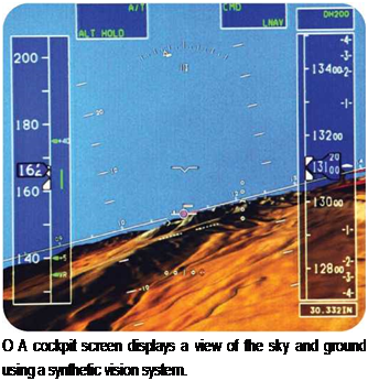
Synthetic Vision System
|
A |
synthetic vision system (SVS) provides pilots with a clear image of the view from their aircraft in all weathers, flying conditions, and visibility levels. A typical system is composed of databases of information that create a virtual reality display in the cockpit. The systems, still in development, are being created to help pilots fly more safely.
Developing a Solution to Poor Visibility
A pilot’s mental image of his or her plane moving in relation to the ground is called situational awareness. If the pilot’s mental image is not the same as what is actually happening in the real world, the pilot has lost situational awareness. When an aircraft is near the ground, or flying near other air traffic, loss of situational awareness can prove
to be deadly. It can cause a plane to fly into an obstacle or lead to a midair collision. It can make a fighter pilot delay ejecting from an aircraft, which can be fatal. If an aircraft flies into an obstacle, or water, while under control, this is called Controlled Flight into Terrain, or CFIT. In general aviation, CFIT is the leading cause of accidents.
Synthetic vision systems are being developed to give the pilot a clear view of the surrounding ground, no matter how bad the visibility is. The research and development work is being carried out jointly by four NASA establishments—Langley Research Center, Ames Research Center, Dryden Flight Center, and Glenn Research Center in partnership with the FAA (Federal Aviation Administration) and the aviation industry. The research aims to cut fatal accidents by 80 percent in ten years and by 90 percent in twenty-five years by making every flight as safe and easy as a flight on a clear, sunny day.
An SVS improves a pilot’s situational awareness by creating a threedimensional (3D) image of the ground below. The image is not from a camera—it is generated from a computer database stored in the aircraft. The database uses
О Poor visibility is a common factor in air accidents. A pilot often cannot see the ground clearly because of low cloud, fog, rain, or darkness. In such conditions, it is possible to fly dangerously close to mountains or other obstacles.
![]()
 –
–
MEASURING EARTH’S SHAPE
The Space Shuttle Radar Topography Mission measured the shape of about 80 percent of Earth’s surface. It created an image of the ground below by using radar instead of light. Radar was used because it can see through clouds and make images at night. Two radar images of the same spot on the ground were taken every 100 feet (30 meters). The images were taken from slightly different points using two radar antennae. One was inside the Space Shuttle’s payload bay. The other was at the end of a 195-foot (59- meter) mast that extended from one side of the Space Shuttle. The differences between the two images allowed the height of the ground to be calculated. This process is called interferometry. The information allows a computer to generate a detailed map of Earth’s surface that shows the shape and height of the ground.
information that was collected by the Space Shuttle during the Space Shuttle Radar Topography Mission in 2000.
Creating Virtual Reality
The synthetic vision database does not just show Earth’s surface shape. It also contains details of obstacles such as bridges, towers, and pylons. A full-color
moving image appears on a flat panel display, like a computer screen, in the cockpit. The screen display looks like an image from a flight simulator computer game, but SVS is much more advanced than a game. It generates a 3D view of the ground in real time. As a plane flies along, GPS satellite navigation tells the synthetic vision system where it is. The image of the ground moves past just like the real view from the plane’s window, but the SVS image is always bright and clear whatever the weather conditions or time of day.
Weather information can be added to the image to show nearby storms. The screen also can display the correct approach path to an airport. This can make a difficult approach to an airport easier and safer to fly. When a plane is on the ground at an airport, the display
shows a plan of the airport. When the pilot is given permission to taxi, the ground controller’s directions can be sent straight to the plane’s synthetic vision system via a radio link. If the plane should stray off the taxiway or onto a runway by mistake, the system automatically sounds a warning in the airplane’s cockpit.


