. Sergeant Popkin — The. Fourth Claim
Sergeant Cedric Basset Popkin, Machine Gunner 1st Class, was in charge of four Vickers machine guns located on the top and on the south facing dope of the Morlancourt Ridge, with the Somme canal and river below. He belonged to the 24th Machine Gun Company, 11th Brigade, 4th Australian Division under Brigadier-General lames Caiman.
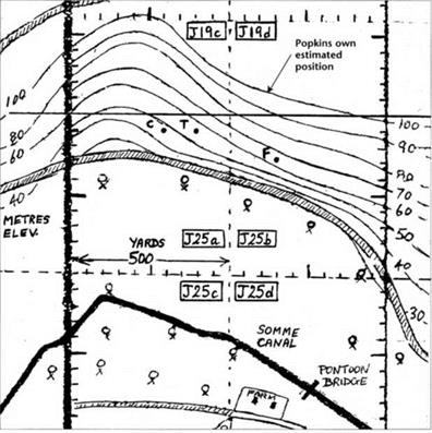
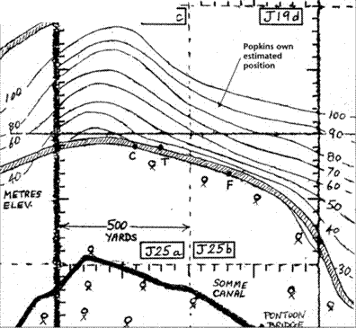
The confusion over the exact position of Private Rupert Weston’s Vickers gun when sergeant Popkin assumed control of it and fired at the red Triplane may again be due to the imultaneous use of different vintages of field maps. Popkin stated in his report that he was omewhere inJ.19.d. On the April 1918 map that omewhat imprecise location would place him at east HM> yards south (down the slope) of where he -.ceded to be to have the required field of fire. On лп August 1917 map, sub-square J19.d is placed yards north of the April 1918 map position md now has the required field of fire.
Sergeant Popkin fired twice at the Triplane. The first time was as it chased May’s Camel along :he face [below] of the Morlancourt Ridge over the mud flats. The two aeroplanes had passed Darbyshires pontoon bridge [off to their left] and vere approaching the sharp bend in the river. According to Private Weston, the aircraft were down at tree-top height when Popkin grabbed the machine gun; Weston was then relegated to being econd man on his own weapon. Popkin placed the Triplane at about 60 feet 118 metres] above the ground. He allowed the Camel to pass and then tired about 80 rounds at the right-hand side of it rrom a range of 100-150 yards. Over the trees, the Triplane entered a zone of very choppy air and its bouncing movement in the sky made Popkin believe that he had scored some hits. He was soon dissuaded of this impression for as soon as the Triplane left the trees behind it steadied and continued the chase with an immediate climb up the steep slope of the Ridge as the river bent round to the south. With the Triplane at about 60 feet above the water and Popkins machine gun at 70 to 130 feet, he would have been firing somewhere between level and downwards.
The Triplane now headed over the Ridge in the direction of the 18-pounder batteries. Popkin turned his gun to the north-west looking up the slope in case the fighter should reappear if it turned round and headed back eastwards. Moments later his readiness was rewarded by the sight of the red plane indeed coming back over the edge of the Ridge, heading south-east towards the brickworks.
After the Triplane had escaped the attentions of Gunners Buie and Evans, Popkin fired his second burst of 80 rounds but nothing available written down by either Popkin or Weston gives us any indication of range. Weston, temporarily degraded to feeding the ammunition belt straight, gave the Triplane’s height as 300 feet above the ground, which on the way to Sainte Colette, is already 250 feet above the river, so the Triplane was about 450 feet above them. Popkin, having now traversed the gun towards the north-west, fired upwards and at the right-hand side of the approaching Triplane which was about one third of the way between the 53rd Battery and the place where it came to earth, and was about to cross his line of fire at a right angle. Measurements on a map put the range at 800 to 850 yards.
During Popkins burst of fire, the distant Triplane’s nose lifted up almost vertically and the fighter rolled to the right. This can easily be interpreted as what would happen to a right – handed pilot, hit in the right side; the reaction would be to pull the stick back towards the right shoulder. The Triplane levelled out again and began a steep descent towards Sainte Colette. The few who had seen the action, congratulated the sergeant on his shooting.
In other documentation Popkin states that his gun position was about 1,000 yards south-east of the 53rd Battery |over the Ridge and out of his sight] and his 1918 submission includes: ‘The distance from the spot where the plane crashed and my gun was about 600 yards.’
The above two estimated distances meet in the south-west quadrant of map sub-square J.19.d. From the junction, a line drawn 150 yards southwest meets a stretch of the flight paths of
Lieutenant May and von Richthofen as they approached the sharp bend in the river. Although no precise spot can be determined, Popkin s story seems good enough.
Far from Sergeant Popkin s shooting being a case of expert marksmanship, from his own words we can deduce that for the first burst he failed to ‘lead’ the target sufficiently. For the second burst, which required a lead of eight to nine fuselage lengths, he apparently ‘calculated incorrectly again, for if…. if’ after he hit the target, it was with only one shot at the edge of the wide spread of the cone of bullets shortly after he began firing.
Three tangential aspects of the event are worth mentioning:
1. The question arises as to why at least one of the
other three machine guns of Popkin s detachment did not open fire. The answer is an example of Murphys Law. Things were quiet that morning. Both sides were ‘resting’ and preparing for renewed fighting in the near future. Lunch time was about an hour away and someone had decided that fish would be tastier then normal army tare. There was a large, shallow lake beside the canal 500 yards away, and if a hand grenade or two were accidentally dropped into the water and exploded!
2. Sergeants in charge of detachments do not have a designated machine gun. When Popkin took over Private Weston s gun and ceased to supervise the others, the odds are that, not having received direct orders, those of their crews who had not gone fishing, just stood about and watched. And it all happened in a few seconds. (Fortunately for the Sergeants stripes, other reasons were accepted by the Lieutenant for the curious failure.)
3. The approximate map reference positions for Private Westons Vickers gun given by others (lltli Brigade HQ: J.25.a.6.9; Lt Travers: J.25.a.8.9; Lt Fraser: J.25.b.3.7;), when plotted on an April 1918 map. are all in exposed positions spread along the Corbie to Vaux-sur-Somme road which is at the same elevation as the mud flats beside the Canal. Given the sheltered, scrub-covered, higher ground just to the north, such low sitings are illogical; a person would have to try hard to find worse positions. The locations given are obviously a little odd.
Lieutenants Travers and Fraser were competent officers so should not be guilty of such slips. Fraser on one occasion stated that he heard a strong burst of fire coming from the south-east corner of the woods; not from down by the road. The present authors plotted the three strange gun positions on an August 1917 map and noted their positions on the contour lines. They immediately became sheltered positions in the scrub to the north, especially J.25.b.3.7 given by Fraser, which thereupon fell close to the south-west quadrant of J.19.d on the 1918 map. This is where Popkin himself said he was positioned. (There is no reason to assume that April 1918 maps were distributed to everyone at once, and some of the 11 th Brigade may still have been using old maps, which in any event looked very similar to earlier ones.) Add in that there were four machine guns, each some distance from the others, and no one knows beside which of them Popkin was standing when he spoke to the officers who later approximated the NCO’s position.
In sum: assuming that the Triplane was not in some strange attitude at the time. Sergeant Popkin s shot would have approached the fuselage of the Triplane at the angles, both vertical and horizontal, from which the fatal one had come. His machine gun was situated in roughly the same plane as the long axis of the German Triplane and the range was within the normal limits for a bullet to be found inside the clothing near the exit wound.
|
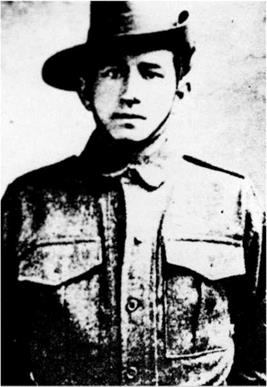
Sgt Cedric Bassett Popkin, 24th MGC. |
SERGEANT POPKIN – THE FOURTH CLAIM
Map 62D August 1917
SCT. POPKIN’S POSITION as per:
C. 25a 6. 9 General Cannan’s HQ.
T. 25a 8. 9 Lt Travers
F. 25b 3. 7 Lt Fraser
Note the dots ( • ) relative to the 40m, 50m and 60m contour lines. These have good cover and a good field of fire against the expected German army attack across the canal. They are excellent defensive positions.
Map 62D April 1918
SGT. POPKIN’S POSITION as per officers’ cited above and self.
The August 1917 references when plotted on an April 1918 map are depicted mainly along the road at the foot of the slope. This is 100 yds south of the true position (see top map) and would have no cover against Germans advancing across the river, nor a good field of fire.

![]()
![]()
 These positions, if true, would have had little defensive value.


