What We Learned
Viking 1 was launched from Cape Canaveral on August 20, 1975. Its twin was launched on September 9, 1975, and Viking 2 reached Mars on August 7, 1976, a few weeks after the first triumphant landing. The second lander reached a site several thousand miles away at Utopia Planitia on September 3, 1976, after suffering its own small mishaps. The downward looking radar was probably confused by a rock or reflective surface, so the thrusters fired too long, cracking the soil and throwing up dust. It stopped with one leg resting on a rock, tilting the lander by eight degrees. Otherwise, it was unharmed. The hardware was designed to last for ninety days but proved to be very durable.36 Viking 1’s orbiter lasted nearly two years and Viking 2’s orbiter lasted just over four years. Meanwhile, on the surface, the Viking 2 lander ceased operating when its battery failed after three and a half years, while the indomitable Viking 1 lander was going strong after more than six years, when simple human error during a software update made the antenna retract and communication with the Earth was lost.37
Public attention focused on the landers, with their life detection experiments and “you are there” images, but the orbiters were also very important in shaping a modern view of Mars. The orbiters carried the landers to Mars, scouted for landing sites, and relayed lander data back to Earth. Each equipped with optical and infrared imagers, they mapped 97 percent of the surface and sent back over 46,000 images. They could see features 150 to 300 meters across anywhere on the planet, and in selected areas they could resolve features the size of a small house.38 Whereas Mariner had only seen old, cratered terrain, the Vikings saw a rich and varied topography and geology. There were immense volcanoes, corrugated lava plains, deep canyons, and wind-carved features. The planet was divided into northern low plains and southern highlands that were pock-marked with craters. Mars had extensive elevated regions of volcanism, although no areas of fresh lava. There was weather: dust storms, pressure variations, and gas circulation between the poles. As NASA’s Thomas Mutch said of the Viking orbiter images, “They show Mars as an extremely diverse planet. . . . It is difficult to avoid the conclusion that, though Viking contributed immeasurably to breaking the code of the Mars enigma, we do not yet confidently understand its dramatic and turbulent past.”39
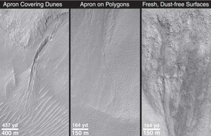
Most excitingly, Viking provided indirect but compelling evidence for water. Not currently—the air is so cold and thin that a cup of water placed on the surface would evaporate away in seconds. But the orbiters sent back images of rock formations all over Mars that could only have been produced by the action of
|
Figure 2.2. Four decades after Mariner 9 saw the first signs that Mars had been wet in the ancient past, the evidence for geological formations that can only result from the action of water has grown much stronger. In these images from the Mars Global Surveyor mission, features are suggestive of episodic eruptions of sub-surface water, altering the landscape before the water evaporates and boils into space (NASA/Jet Propulsion Laboratory). |
large amounts of liquid water in the past. Huge river valleys were seen, and places where it looked like rivers had once fanned out into a spider’s web of channels that ended in ancient shallow seas. The flanks of volcanoes had grooves that on Earth indicate water erosion. Many craters had shapes that were consistent with the impactor landing in mud. Other regions of chaotic terrain looked as if they had collapsed when underground volcanism melted ice, which then flowed away as water. The water flows implied by these features were equal to the greatest rivers on Earth (figure 2.2).40


