STS-99
 2000-010A 11 February 2000
Pad 39A, Kennedy Space Center, Florida 22 February 2000
Runway 33, Shuttle Landing Facility, KSC, Florida OV-105 Endeavour/ET-92/SRB BI-100/SSME #1 2052; #2 2044; #3 2047 11 days 5hrs 39 min 41 sec Endeavour
Acquisition of high-resolution topographical map of Earth’s land masses (between 60°N and 56°S) by radar
Flight Crew
KREGEL, Kevin Richard, 43, civilian, commander, 4th mission Previous missions: STS-70 (1995); STS-78 (1996); STS-87 (1997)
GORIE, Dominic Lee Pudwell, 42, USN, pilot, 2nd mission Previous mission: STS-91 (1998)
THIELE, Gerard Paul Julius, 46, civilian, ESA mission specialist 1 KAVANDI, Janet Lynn, 40, civilian, mission specialist 2, 2nd mission Previous mission: STS-91 (1998)
VOSS, Janice Elaine, 43, civilian, mission specialist 3, payload commander,
5th mission
Previous missions: STS-57 (1993); STS-63 (1995); STS-83 (1997); STS-94 (1997) MOHRI, Mamoru Mark, 52, civilian, Japanese, mission specialist 4,
2nd mission
Previous mission: STS-47 (1992)
Flight Log
The Shuttle Radar Topography Mission (SRTM) used modified versions of the radar instruments that had flown on the two SRL Shuttle missions in 1994. In addition to providing the topographical radar images of Earth, the mission also tested new technologies for the deployment of large, ridged structures in space, and recorded measurements of their distortion to an extremely high precision. Space-borne imaging radar from the Shuttle had previously been flown on STS-2 (SIR-A) in 1981 and STS 41-G (SIR-B) in 1984, as well as a German experiment on STS-9 (Spacelab 1) in 1983 and the two SRL Shuttle missions (SIR-C) in 1994.
The launch date of STS-99 was originally set for 16 September 1999, but was postponed until October due to the Shuttle fleet wiring concerns and the subsequent remedial action. With so much work to do on the wiring issue, it was decided to launch
|
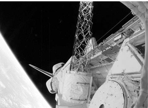
Part of the Shuttle Radar Topography Mission hardware is photographed through Endeavour’s aft flight deck windows about half-way through the scheduled 11-day SRTM flight. The mast, only partially visible in the centre, is actually 61 metres in length |
STS-99 no earlier than 19 November, and for a while, either the radar mission or the Hubble service mission (STS-103) could have flown first. In October, it was decided to fly the Hubble mission before STS-99. The SRTM launch therefore slipped to 13 January 2000 and then, after a review, to 31 January. That attempt was scrubbed at the T — 9 minute mark due to adverse weather. Then the launch moved from 9 to 11 February in order to work on some minor technical issues, three of which had to be addressed during the planned T — 9 minute hold on the day of launch delaying lift-off by about 14 minutes.
Once in orbit, the crew configured the vehicle for its orbital science mission. This included extending the SRTM to its full mast length of 61 metres from the payload bay over Endeavour’s left wing. After checking out the orbiter and payload, the mapping began some 12 hours into the mission. The crew worked in two 12-hour shifts, with Kregel, Thiele and Kavandi as Red Shift and Gorie, Voss and Mohri as Blue Shift, and the mission was flown using an attitude hold period for radar mapping and flying the orbiter in a tail-first configuration. One pair of radar antennas were in the payload bay, with the other pair at the end of the boom, providing stereo images of the ground the vehicle flew over in C-band and X-band wavelengths, recording data in two wavelengths from two locations simultaneously. This would also provide 3D maps after the mission that were thirty times more accurate than any previous attempts.
Tests were also made on gas jets located at the end of the boom to absorb the firing of the orbiter’s thrusters. Alignment of the radar sensors was vital for accurate data, but it was essential to reduce the strain on the mast when the vehicle was moved. By firing a brief RCS burn, the mast deflected slightly backwards and then rebounded forward. Once returned to vertical, a stronger RCS thrust was applied, arresting the mast’s motion but increasing the orbital speed of the vehicle. It was noted on FD 2 that orbiter propellant usage had been higher than expected due to the failure of a cold gas thruster system on the end of the mast to offset the gravity gradient torque. This meant that more propellant was being used to maintain the attitude of the vehicle for data sweeps. Measurements were taken to reduce fuel expenditure and it was determined that enough propellant could be saved to complete the full mission as planned.
At the end of data gathering on FD 10, a total of 222 hours and 23 minutes of mapping had been achieved, covering 99.98 per cent of the planned mapping area once and 94.6 per cent of it twice. There remained only 207,000 km2 (80,000 miles2) in scattered areas uncovered, but most of this was in North America, which had previously been well-mapped. Over 123.2 million km2 (47.6 million miles2) had been mapped, with enough data on 32 high-density tapes aboard Endeavour to fill 20,000 CDs, or the entire book content of the US Library of Congress. It was estimated that it would take over two years to fully process the data.
Also aboard Endeavour was a student experiment called EarthKam, which took 2,715 digital photos during the mission through an overhead flight deck window. Students from 84 participating middle schools around the world could select photo targets and receive images via the Internet, supporting their class work in Earth science, geography, maths and space sciences. The landing was achieved on the second opportunity at KSC, with the first attempt having been waived off due to high crosswinds at the SLF.
Milestones
215th manned space flight
127th US manned space flight
97th Shuttle mission
14th flight of Endeavour
5th Shuttle mission featuring imaging radar


